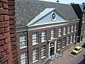
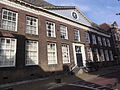
Category:Oud Burger Mannen- en Vrouwenhuis, Tiel
Jump to navigation
Jump to search
| Object location | | View all coordinates using: OpenStreetMap |
|---|
building in Tiel, Netherlands  | |||||
| Upload media | |||||
| Instance of | |||||
|---|---|---|---|---|---|
| Location | Tiel, Gelderland, Netherlands | ||||
| Street address |
| ||||
| Located on street | |||||
| Heritage designation |
| ||||
 | |||||
|
This is a category about rijksmonument number 35559
|
| Address |
|
Media in category "Oud Burger Mannen- en Vrouwenhuis, Tiel"
The following 8 files are in this category, out of 8 total.
-
 Achtergevel Weesshuis - Tiel - 20208970 - RCE.jpg 1,200 × 806; 211 KB
-
 Gezien naar het westen vanaf nummer 22 - Tiel - 20208963 - RCE.jpg 1,200 × 959; 220 KB
-
 Oud Burger Mannen- en Vrouwenhuis Tiel 1306 - 078.jpg 2,380 × 2,171; 1.2 MB
-
 Oud Burger Mannen- en Vrouwenhuis Tiel 1306 - 083.jpg 2,650 × 2,290; 1.48 MB
-
 Oud Burger Mannen- en Vrouwenhuis Tiel 1306 - 084.jpg 3,655 × 2,577; 1.97 MB
-
 T.T Oud-Burger Mannen-en-Vrouwenhuis Tiel.JPG 1,280 × 960; 479 KB
-
 Tiel Rijksmonument 35559 Ambtmanstraat 24.JPG 3,648 × 2,736; 3.46 MB
-
 Voorgevel gezien van rechts - Tiel - 20208930 - RCE.jpg 888 × 1,200; 257 KB


