Category:Oude Delft 47
Jump to navigation
Jump to search
| Object location | | View all coordinates using: OpenStreetMap |
|---|
 | |||||
| Upload media | |||||
| Instance of |
| ||||
|---|---|---|---|---|---|
| Location | Delft, South Holland, Netherlands | ||||
| Street address |
| ||||
| Located on street | |||||
| Heritage designation |
| ||||
 | |||||
|
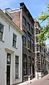
This is a category about rijksmonument number 11984
|
| Address |
|
Media in category "Oude Delft 47"
The following 14 files are in this category, out of 14 total.
-
 Delft - Oude Delft 47.jpg 1,452 × 2,519; 1.12 MB
-
 Detail trap - Delft - 20052462 - RCE.jpg 1,200 × 1,200; 266 KB
-
 Gang - Delft - 20052456 - RCE.jpg 953 × 1,200; 157 KB
-
 Gevel - Delft - 20052414 - RCE.jpg 804 × 1,200; 224 KB
-
 Overzicht achtergevels - Delft - 20052454 - RCE.jpg 1,186 × 1,200; 286 KB
-
 Overzicht achtergevels - Delft - 20052455 - RCE.jpg 1,195 × 1,200; 267 KB
-
 Plafond achterkamer parterre - Delft - 20052465 - RCE.jpg 1,192 × 1,200; 298 KB
-
 Schoorsteenmantel in achterkamer parterre - Delft - 20052464 - RCE.jpg 945 × 1,200; 154 KB
-
 Stucwerk boven deur in achterkamer - Delft - 20052463 - RCE.jpg 1,195 × 1,200; 206 KB
-
 Stucwerk boven deur ingang - Delft - 20052457 - RCE.jpg 1,189 × 1,200; 258 KB
-
 Stucwerk plafond gang - Delft - 20052458 - RCE.jpg 1,185 × 1,200; 248 KB
-
 Stucwerk plafond gang - Delft - 20052459 - RCE.jpg 1,184 × 1,200; 272 KB
-
 Trappenhuis - Delft - 20052460 - RCE.jpg 1,191 × 1,200; 196 KB
-
 Trappenhuis - Delft - 20052461 - RCE.jpg 1,181 × 1,200; 231 KB


