Category:Oude Gouwsboom
Jump to navigation
Jump to search
| Object location | | View all coordinates using: OpenStreetMap |
|---|
 | |||||
| Upload media | |||||
| Instance of | |||||
|---|---|---|---|---|---|
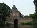
| Location | Enkhuizen, North Holland, Netherlands | ||||
| Street address |
| ||||
| Heritage designation | |||||
 | |||||
|
This is a category about rijksmonument number 464875
|
| Address |
|
Media in category "Oude Gouwsboom"
The following 13 files are in this category, out of 13 total.
-
 20100613 Oude Gouwsboom Enkhuizen.jpg 3,264 × 2,448; 2.4 MB
-
 Bastion V en Courtine V-VI, Enkhuizen.jpg 3,888 × 2,592; 5 MB
-
 Courtine V-VI met Oude Goudsboom.JPG 2,592 × 3,888; 5.36 MB
-
 Handvestwater - Enkhuizen - 20070054 - RCE.jpg 1,186 × 1,200; 444 KB
-
 Oude Gouwsboom1 Enkhuizen.jpg 4,896 × 3,672; 2.01 MB
-
 Oude Gouwsboom2 Enkhuizen.jpg 4,896 × 3,672; 2.12 MB
-

-
 Overzicht, vesting Oude Gouwsboom - Enkhuizen - 20070056 - RCE.jpg 1,195 × 1,200; 440 KB
-
 Overzicht, vesting Oude Gouwsboom - Enkhuizen - 20070057 - RCE.jpg 1,192 × 1,200; 351 KB
-
 Vesting met Oude Gouwsboom - Enkhuizen - 20070052 - RCE.jpg 1,188 × 1,200; 258 KB
-
 Vesting met Oude Gouwsboom - Enkhuizen - 20070053 - RCE.jpg 1,192 × 1,200; 259 KB
-
 Waterpoorthuisje Oude Gouwsboom Enkhuizen.jpg 3,672 × 4,896; 1.58 MB
-


