Category:Oudegracht 167, Utrecht
Jump to navigation
Jump to search
| Object location | | View all coordinates using: OpenStreetMap |
|---|
 | |||||
| Upload media | |||||
| Instance of | |||||
|---|---|---|---|---|---|
| Location | Utrecht, Netherlands | ||||
| Street address |
| ||||
| Located on street | |||||
| Heritage designation |
| ||||
 | |||||
|
This is a category about rijksmonument number 514250
|
| Address |
|
Media in category "Oudegracht 167, Utrecht"
The following 13 files are in this category, out of 13 total.
-
 Beeld Nijverheid Stadhuisbrug.jpg 4,608 × 3,456; 6.86 MB
-
 Bibliotheek Utrecht.jpg 2,816 × 2,112; 2.92 MB
-
 BoekhandelBroeseUtrecht.jpg 2,048 × 1,536; 846 KB
-
 Exterieur OVERZICHT - Utrecht - 20314966 - RCE.jpg 1,200 × 1,197; 325 KB
-
 Krantenadvertentie omtrent heropening Vroom en Dreesmann te Utrecht in 1925.jpg 4,183 × 5,884; 2.63 MB
-
 Ornamenten V&D Choorstraat Utrecht.jpg 3,333 × 5,383; 11.6 MB
-
 Oudegracht 167 en Choorstraat 3 en 5 te Utrecht gezien in 1994.jpg 3,543 × 2,776; 3.38 MB
-
 Oudegracht 167 te Utrecht met glas in lood in de vide.jpg 3,868 × 3,225; 7.28 MB
-
 Oudegracht 167.jpg 2,016 × 1,347; 644 KB
-
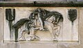
 Relief lam Stadshuisbrug.JPG 4,608 × 3,456; 7.8 MB
-
 St Maarten Termote Dresmé V-D Choorstraat Utrecht.jpg 2,584 × 1,492; 2.81 MB
-
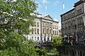
 Stadshuisbrug met Broese.jpg 2,816 × 2,112; 2.97 MB
-
 Utrecht Altstadt 13.jpg 4,546 × 3,255; 4.17 MB


