Category:Oudegracht 239, Alkmaar
Jump to navigation
Jump to search
| Object location | | View all coordinates using: OpenStreetMap |
|---|
 | |||||
| Upload media | |||||
| Instance of |
| ||||
|---|---|---|---|---|---|
| Location | Alkmaar, North Holland, Netherlands | ||||
| Heritage designation |
| ||||
 | |||||
|
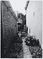
This is a category about rijksmonument number 7340
|
| Address |
|
Media in category "Oudegracht 239, Alkmaar"
The following 13 files are in this category, out of 13 total.
-
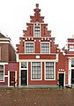 Alkmaar-Oudegracht 239.jpg 1,686 × 2,406; 564 KB
-
-

-

-

-
 Oudegracht 239. De achtertuin. Rijksmonument uit 1623. - RAA011005995 - RAA Elsinga.jpg 2,574 × 1,875; 930 KB
-
 Oudegracht 239. De achtertuin. Rijksmonument uit 1623. - RAA011005998 - RAA Elsinga.jpg 1,883 × 2,584; 956 KB
-
 Oudegracht 239. De achtertuin. Rijksmonument uit 1623. - RAA011005999 - RAA Elsinga.jpg 1,886 × 2,581; 1,004 KB
-

-

-

-

-
 Voorgevels - Alkmaar - 20006648 - RCE.jpg 943 × 1,200; 269 KB


