Category:Oudegracht 346, Utrecht
Jump to navigation
Jump to search
| Object location | | View all coordinates using: OpenStreetMap |
|---|
 | |||||
| Upload media | |||||
| Instance of |
| ||||
|---|---|---|---|---|---|
| Location | Utrecht, Netherlands | ||||
| Street address |
| ||||
| Located on street | |||||
| Heritage designation |
| ||||
 | |||||
|
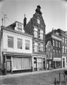
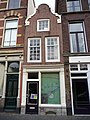
This is a category about rijksmonument number 31107
|
| Address |
|
Media in category "Oudegracht 346, Utrecht"
The following 5 files are in this category, out of 5 total.
-
 Exterieur VOORGEVEL - Utrecht - 20305965 - RCE.jpg 953 × 1,200; 242 KB
-
 Exterieur VOORGEVEL - Utrecht - 20305966 - RCE.jpg 959 × 1,200; 274 KB
-
 Oudegracht 346.JPG 2,592 × 3,456; 4.31 MB
-
 Voorgevel - Utrecht - 20236845 - RCE.jpg 806 × 1,200; 197 KB
-
 Voorgevels - Utrecht - 20236847 - RCE.jpg 806 × 1,200; 227 KB


