Category:Oudkerkhof 27, Utrecht
Jump to navigation
Jump to search
| Object location | | View all coordinates using: OpenStreetMap |
|---|
house in Utrecht, Netherlands  | |||||
| Upload media | |||||
| Instance of | |||||
|---|---|---|---|---|---|
| Location | Utrecht, Netherlands | ||||
| Street address |
| ||||
| Architect | |||||
| Heritage designation |
| ||||
| Inception |
| ||||
 | |||||
|
This is a category about rijksmonument number 514238
|
| Address |
|
Media in category "Oudkerkhof 27, Utrecht"
The following 3 files are in this category, out of 3 total.
-
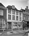 Exterieur VOORGEVEL - Utrecht - 20305916 - RCE.jpg 959 × 1,200; 216 KB
-
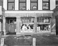 Onderpui van een voorgevel, NBBS Reizen - Utrecht - 20400360 - RCE.jpg 1,200 × 960; 227 KB
-
 Oudkerkhof 27.JPG 3,456 × 5,184; 6.19 MB

