Category:Overduin, Oostkapelle
Jump to navigation
Jump to search
| Object location | | View all coordinates using: OpenStreetMap |
|---|
building in Veere, Netherlands  | |||||
| Upload media | |||||
| Instance of | |||||
|---|---|---|---|---|---|
| Part of | |||||
| Location | Oostkapelle, Zeeland, Netherlands | ||||
| Street address |
| ||||
| Heritage designation |
| ||||
 | |||||
|
This is a category about rijksmonumentcomplex number 530001
|
Hoofdgebouw:
|
This is a category about rijksmonument number 530002
|
Historische tuin- en parkaanleg:
|
This is a category about rijksmonument number 530003
|
Koetshuis:
|
This is a category about rijksmonument number 530004
|
Boerderij:
|
This is a category about rijksmonument number 530005
|
Landbouwschuur:
|
This is a category about rijksmonument number 530006
|
Prieel "rode tent":
|
This is a category about rijksmonument number 530007
|
Tuinmanswoning:
|
This is a category about rijksmonument number 530008
|
IJskelder:
|
This is a category about rijksmonument number 530641
|
Bakkeet:
|
This is a category about rijksmonument number 530642
|
| Address |
|
Subcategories
This category has the following 2 subcategories, out of 2 total.
K
- Koetshuis, Overduin (4 F)
T
- Tuinmanswoning, Overduin (3 F)
Media in category "Overduin, Oostkapelle"
The following 32 files are in this category, out of 32 total.
-
 Achtergevel - Oostkapelle - 20175466 - RCE.jpg 1,200 × 959; 246 KB
-
 Achtergevel vanuit tuin - Oostkapelle - 20175467 - RCE.jpg 1,192 × 1,200; 496 KB
-
 Achterzijde - Oostkapelle - 20175468 - RCE.jpg 1,188 × 1,200; 429 KB
-
 Gang 1e etage - Oostkapelle - 20175483 - RCE.jpg 967 × 1,200; 184 KB
-
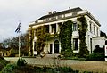 Overduin front.jpg 2,154 × 1,476; 420 KB
-
 Overduin park.jpg 2,154 × 1,476; 464 KB
-
 Overduin.jpg 3,008 × 2,000; 939 KB
-
 Overzicht tuin, vanaf bordes - Oostkapelle - 20352671 - RCE.jpg 1,188 × 1,200; 323 KB
-
 Overzicht vanuit voortuin - Oostkapelle - 20175462 - RCE.jpg 1,200 × 962; 276 KB
-
 Overzicht voorgevel - Oostkapelle - 20175463 - RCE.jpg 1,200 × 937; 292 KB
-
 Overzicht voorgevel en rechter zijgevel - Oostkapelle - 20352672 - RCE.jpg 1,200 × 943; 257 KB
-
 Parterre kleine zijkamer (schouw) - Oostkapelle - 20175477 - RCE.jpg 973 × 1,200; 194 KB
-
 Parterre kleine zijkamer - Oostkapelle - 20175478 - RCE.jpg 951 × 1,200; 192 KB
-
 Parterre rechts voor - Oostkapelle - 20175475 - RCE.jpg 1,200 × 952; 216 KB
-
 Parterre rechts voor met schoorsteenmantel. - Oostkapelle - 20175476 - RCE.jpg 961 × 1,200; 219 KB
-
 Parterre zitkamer - Oostkapelle - 20175479 - RCE.jpg 968 × 1,200; 197 KB
-
 Plafond tuinkamer - Oostkapelle - 20175482 - RCE.jpg 1,200 × 951; 149 KB
-
 Rechterzijgevel - Oostkapelle - 20175465 - RCE.jpg 1,200 × 956; 246 KB
-

-

-

-

-

-
 Schouw in kamer 1e etage - Oostkapelle - 20175484 - RCE.jpg 949 × 1,200; 136 KB
-
 Schuur van tuinmanswoning - Oostkapelle - 20175474 - RCE.jpg 1,190 × 1,200; 466 KB
-

-

-
 Tuinaanleg - Oostkapelle - 20175459 - RCE.jpg 926 × 1,200; 370 KB
-
 Tuinkamer - Oostkapelle - 20175480 - RCE.jpg 1,200 × 954; 192 KB
-
 Tuinkamer - Oostkapelle - 20175481 - RCE.jpg 1,200 × 957; 195 KB
-
 Voor- en linkerzijgevel - Oostkapelle - 20175464 - RCE.jpg 1,200 × 947; 248 KB
-
 Voorgevel en rechter zijgevel - Oostkapelle - 20175452 - RCE.jpg 1,200 × 809; 217 KB


_-_Oostkapelle_-_20175477_-_RCE.jpg)


