Category:Paleontological Research Institution diagrams
Jump to navigation
Jump to search
Media in category "Paleontological Research Institution diagrams"
The following 19 files are in this category, out of 19 total.
-
 Basin Range Faulting.tif 1,200 × 480; 586 KB
-
 Cross-bed Dune Formation.tif 2,250 × 1,050; 13.62 MB
-
 Erosion-spires-SW48.tif 2,200 × 2,791; 17.6 MB
-
 Features of Subduction Zones.tif 2,760 × 2,282; 18.04 MB
-
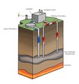 Geothermal Power Station.tif 2,000 × 2,130; 12.21 MB
-
 Glacial Compact.pdf 1,047 × 600; 113 KB
-
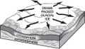
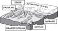 Glacial Features.pdf 1,210 × 650; 121 KB
-
 Grand Canyon Stratigraphic Units.tif 3,454 × 2,860; 28.31 MB
-
 Grand Staircase Stratigraphic Units.tif 3,193 × 1,869; 17.1 MB
-
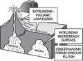 Intrusive-Extrusive Igneous Features.pdf 1,085 × 802; 89 KB
-
 Mississippi River Floodplain.tif 945 × 1,637; 4.45 MB
-
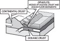 Ophiolite Formation.pdf 1,127 × 764; 207 KB
-
 Rain Shadow.tif 1,868 × 1,178; 459 KB
-
 Salt Cavern.tif 2,400 × 2,871; 19.74 MB
-
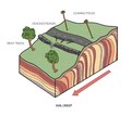 Soil Creep.tif 2,004 × 1,787; 10.27 MB
-
 South Central US Sedimentary Basins.tif 2,657 × 3,106; 32.04 MB
-
 Southwestern US Sedimentary Basins.tif 5,067 × 4,133; 80.44 MB
-
 Subduction Zone Stratovolcano.tif 2,444 × 1,800; 12.61 MB
-
 Utah Cretaceous Coal Swamps.tif 3,250 × 2,250; 28.48 MB