Category:Park Road South, Birkenhead
Jump to navigation
Jump to search
| Object location | | View all coordinates using: OpenStreetMap |
|---|
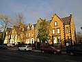
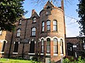
Park Road South, unsurprisingly forms the southern boundary of Birkenhead Park. It is a major route westwards from Birkenhead centre to Claughton Village.
Subcategories
This category has the following 11 subcategories, out of 11 total.
2
8
9
A
- Abbots Grange, Birkenhead (2 F)
B
- Birkenhead Park School (8 F)
C
- Cannon Hill, Birkenhead (3 F)
- Cannon Mount, Birkenhead (3 F)
Q
Media in category "Park Road South, Birkenhead"
The following 11 files are in this category, out of 11 total.
-
 12 and 14 Park Road South, Birkenhead.jpg 4,608 × 3,456; 4.23 MB
-
 16 and 18 Park Road South, Birkenhead.jpg 4,608 × 3,456; 4.87 MB
-
 20-30 Park Road South, Birkenhead.jpg 4,608 × 3,456; 4.73 MB
-
 Benchmark at 12 & 14 Park Road South, Birkenhead.jpg 3,148 × 4,197; 12.51 MB
-
 Benchmark at 62 Park Road South, Birkenhead.jpg 3,330 × 4,440; 11.57 MB
-
 Benkid77 Park Road South, Birkenhead 090809.JPG 3,648 × 2,736; 3.59 MB
-
 Benkid77 Park Road South, Birkenhead 2 090809.JPG 3,648 × 2,736; 3.59 MB
-
 Columba Centre, Birkenhead.jpg 3,240 × 4,320; 4.88 MB
-
 ESWA Sports & Social Club, Birkenhead.jpg 4,320 × 3,240; 4.03 MB
-
 Park Road South, Birkenhead 2020.jpg 5,171 × 3,440; 19.84 MB
-
 Post box at Alvanley Place, Claughton.jpg 3,276 × 4,509; 8.65 MB


