Category:Pasadena, California in the 1880s
Jump to navigation
Jump to search
|
Subcategories
This category has the following 2 subcategories, out of 2 total.
Media in category "Pasadena, California in the 1880s"
The following 15 files are in this category, out of 15 total.
-

-
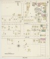
 Sanborn Fire Insurance Map from Pasadena, Los Angeles County, California. LOC sanborn00749 001-1.tif 6,450 × 7,650; 141.17 MB
-

-
 Sanborn Fire Insurance Map from Pasadena, Los Angeles County, California. LOC sanborn00749 001-2.tif 6,450 × 7,650; 141.17 MB
-

-
 Sanborn Fire Insurance Map from Pasadena, Los Angeles County, California. LOC sanborn00749 001-3.tif 6,450 × 7,650; 141.17 MB
-

-
 Sanborn Fire Insurance Map from Pasadena, Los Angeles County, California. LOC sanborn00749 001-4.tif 6,450 × 7,650; 141.17 MB
-

-
 Sanborn Fire Insurance Map from Pasadena, Los Angeles County, California. LOC sanborn00749 001-5.tif 6,450 × 7,650; 141.17 MB
-
 Alta rr.jpg 400 × 270; 80 KB
-
 Devil's Gate, source of Pasadena water supply.jpg 1,102 × 1,793; 1.26 MB
-
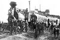
 Funeral of Owen Brown.jpg 637 × 508; 69 KB
-
 Pasadena, Calif1886.jpg 2,109 × 1,507; 950 KB
-
 Residence of E. T. Hurlbut, on Orange Grove Ave, Pasadena.jpg 1,906 × 1,190; 1.27 MB


