Category:Paulusabdij, Utrecht
Jump to navigation
Jump to search
| Object location | | View all coordinates using: OpenStreetMap |
|---|
church in Utrecht, Netherlands  | |||||
| Upload media | |||||
| Instance of | |||||
|---|---|---|---|---|---|
| Part of |
| ||||
| Named after | |||||
| Location | Utrecht, Netherlands | ||||
| Street address |
| ||||
| Occupant |
| ||||
| Heritage designation |
| ||||
| Inception |
| ||||
| Religion or worldview | |||||
 | |||||
Nederlands: De voormalige Paulsabdij in Utrecht
|
This is a category about rijksmonument number 36123
|
| Address |
|
Subcategories
This category has the following 2 subcategories, out of 2 total.
H
N
- Nieuwegracht bij 5, Utrecht (7 F)
Media in category "Paulusabdij, Utrecht"
The following 52 files are in this category, out of 52 total.
-
 1960 - Utrecht - 20231577 - RCE.jpg 800 × 1,200; 248 KB
-
 1960 weinig vernieuwd. - Utrecht - 20231578 - RCE.jpg 1,200 × 800; 218 KB
-

-

-
-
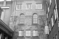
 Detail venster transeptgevel - Utrecht - 20231549 - RCE.jpg 819 × 1,200; 302 KB
-
 Eindmuur kloostervleugel - Utrecht - 20231548 - RCE.jpg 819 × 1,200; 229 KB
-
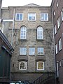
 Exterieur - Utrecht - 20231556 - RCE.jpg 972 × 1,200; 243 KB
-
 Exterieur - Utrecht - 20231557 - RCE.jpg 929 × 1,200; 309 KB
-
 Exterieur - Utrecht - 20231558 - RCE.jpg 1,200 × 1,198; 396 KB
-
 Exterieur - Utrecht - 20231559 - RCE.jpg 1,200 × 1,192; 312 KB
-
 Exterieur - Utrecht - 20231560 - RCE.jpg 1,200 × 923; 251 KB
-
 Exterieur - Utrecht - 20231561 - RCE.jpg 920 × 1,200; 213 KB
-
 Exterieur - Utrecht - 20231562 - RCE.jpg 931 × 1,200; 246 KB
-
 Exterieur MUURFRAGMENT TRANSEPT - Utrecht - 20314310 - RCE.jpg 955 × 1,200; 302 KB
-
 Hofpoort, Runnebaan - Utrecht - 20212465 - RCE.jpg 857 × 1,200; 252 KB
-

-
 Interieur naar het noorden - Utrecht - 20231552 - RCE.jpg 818 × 1,200; 210 KB
-
 Interieur naar het zuiden - Utrecht - 20231551 - RCE.jpg 820 × 1,200; 220 KB
-

-

-

-

-

-

-
 Kelder zuidvleugel - Utrecht - 20231563 - RCE.jpg 1,200 × 1,198; 342 KB
-
 Kelder zuidvleugel - Utrecht - 20231564 - RCE.jpg 1,200 × 1,192; 244 KB
-
 Kelder zuidvleugel - Utrecht - 20231565 - RCE.jpg 1,200 × 1,178; 363 KB
-
 Kelder zuidvleugel - Utrecht - 20231566 - RCE.jpg 1,200 × 1,195; 395 KB
-
 Muur bij transept in noord-oost hoek - Utrecht - 20231554 - RCE.jpg 1,200 × 825; 272 KB
-
 Muur in oostvleugel bij transept west-zijde - Utrecht - 20231546 - RCE.jpg 1,200 × 771; 221 KB
-
 Nieuwegracht 5 extra.JPG 2,592 × 3,456; 4.2 MB
-
 Nieuwegracht 5+.JPG 2,592 × 3,456; 4.25 MB
-
 Opgegraven fundering - Utrecht - 20231542 - RCE.jpg 1,200 × 924; 347 KB
-
 Opgraving - Utrecht - 20231541 - RCE.jpg 1,200 × 950; 360 KB
-
 Paulusabdij 1a.JPG 360 × 480; 43 KB
-
 Paulusabdij 2.JPG 2,112 × 2,816; 2.59 MB
-
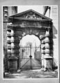
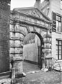
 Pauluspoort te Utrecht.jpg 535 × 374; 58 KB
-

-
 Poort achter Hofpoort, (arrondissementsrechtbank) - Utrecht - 20231576 - RCE.jpg 878 × 1,200; 181 KB
-
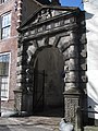
 Poort van Hof van Utrecht - Utrecht - 20236138 - RCE.jpg 888 × 1,200; 257 KB
-
 Poortje achter Hofpoort - Utrecht - 20231543 - RCE.jpg 955 × 1,200; 340 KB
-
 Poortje achter Hofpoort - Utrecht - 20231544 - RCE.jpg 960 × 1,200; 310 KB
-
 Reconstructie opgraving - Utrecht - 20231540 - RCE.jpg 947 × 1,200; 270 KB
-
 Runneboren- Nieuwe Gracht - Utrecht - 20231479 - RCE.jpg 868 × 1,200; 214 KB
-
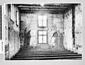
 Statenkamer - Utrecht - 20231555 - RCE.jpg 947 × 1,200; 293 KB
-
 Tegelvloer bij tussenmuur in oostvleugel - Utrecht - 20231545 - RCE.jpg 1,200 × 808; 177 KB
-

-
 Tussenmuur in oostvleugel naar het zuiden - Utrecht - 20231553 - RCE.jpg 1,200 × 817; 248 KB
-
 Utrecht Hofpoort.JPG 2,736 × 3,648; 4.65 MB
-
 Utrecht Paulusabdij.JPG 1,459 × 1,094; 295 KB
-
 Zuid-transept gevel - Utrecht - 20231547 - RCE.jpg 821 × 1,200; 184 KB


_-_Utrecht_-_20231576_-_RCE.jpg)


