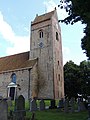
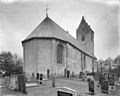
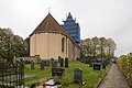
Category:Pauluskerk, Aldtsjerk
Jump to navigation
Jump to search
| Object location | | View all coordinates using: OpenStreetMap |
|---|
church  | |||||
| Upload media | |||||
| Instance of | |||||
|---|---|---|---|---|---|
| Dedicated to | |||||
| Location | Aldtsjerk, Tytsjerksteradiel, Friesland, Netherlands | ||||
| Street address |
| ||||
| Heritage designation |
| ||||
| Inception |
| ||||
| Significant event |
| ||||
| official website | |||||
 | |||||
Nederlands: Pauluskerk (hervormde kerk), Aldtsjerk (Oudkerk)
|
This is a category about rijksmonument number 35669
|
| Address |
|
Subcategories
This category has the following 2 subcategories, out of 2 total.
G
- Grafheuvel Van Sminia (2 F)
I
Media in category "Pauluskerk, Aldtsjerk"
The following 57 files are in this category, out of 57 total.
-
 20180612 Sint-Pauluskerk torenspits Aldtsjerk.jpg 5,184 × 3,456; 2.58 MB
-
 20180612 Sint-Pauluskerk1 Aldtsjerk.jpg 5,184 × 3,456; 3.16 MB
-
 20180612 Sint-Pauluskerk2 Aldtsjerk.jpg 5,184 × 3,456; 2.94 MB
-
 20200902 Sint Pauluskerk1 Aldtsjerk.jpg 5,184 × 3,456; 3.27 MB
-
 20200902 Sint Pauluskerk2 Aldtsjerk.jpg 3,456 × 5,184; 3.69 MB
-
 20200902 Sint Pauluskerk3 Aldtsjerk.jpg 3,456 × 5,184; 2.46 MB
-
 20210615 Pauluskerk Aldtsjerk.jpg 4,495 × 2,997; 2.64 MB
-
 20210615 zicht op Pauluskerk Aldtsjerk.jpg 4,727 × 3,151; 2.78 MB
-
 Aldtsjerk, Paulustsjerke (rûnbôgefries).jpg 4,150 × 2,768; 7.94 MB
-
 Aldtsjerk, Paulustsjerke fanút it noardwêst.jpg 2,841 × 1,895; 2.3 MB
-
 Aldtsjerk, Paulustsjerke mei tsjerkhôf.jpg 2,891 × 1,928; 2.31 MB
-
 Aldtsjerk, Paulustsjerke, Moazes en de Tafelen (Underdiel Wet fan de Heare).jpg 5,444 × 3,673; 12.79 MB
-

-
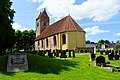
 Aldtsjerk, Paulustsjerke.jpg 5,088 × 3,630; 7.63 MB
-
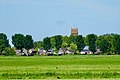
 Aldtsjerk, Van Sminiawei mei Paulustsjerke.jpg 3,244 × 2,037; 2.32 MB
-
 Funderingsrestant aan noordzijde schip - Oudkerk - 20180293 - RCE.jpg 1,200 × 1,199; 297 KB
-
 Funderingsrestant aan noordzijde schip - Oudkerk - 20180294 - RCE.jpg 1,200 × 1,200; 300 KB
-
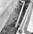 Funderingsrestant aan noordzijde schip - Oudkerk - 20180295 - RCE.jpg 1,193 × 1,200; 299 KB
-
 Funderingsrestant aan noordzijde schip - Oudkerk - 20180296 - RCE.jpg 1,188 × 1,200; 283 KB
-
 Gedeelte noordgevel - Oudkerk - 20180290 - RCE.jpg 1,200 × 961; 350 KB
-
 Gedeelte noordgevel - Oudkerk - 20180291 - RCE.jpg 1,200 × 950; 368 KB
-
 Gedeelte noordgevel - Oudkerk - 20180292 - RCE.jpg 1,200 × 960; 368 KB
-
 Gedeelte van de noordgevel - Oudkerk - 20180307 - RCE.jpg 962 × 1,200; 245 KB
-
 Gedeelte van de zuidgevel - Oudkerk - 20180314 - RCE.jpg 951 × 1,200; 272 KB
-
 Gedeelte zuidgevel - Oudkerk - 20180287 - RCE.jpg 1,200 × 953; 315 KB
-
 Gedeelte zuidgevel - Oudkerk - 20180288 - RCE.jpg 1,200 × 957; 332 KB
-
 Gedeelte zuidgevel - Oudkerk - 20180289 - RCE.jpg 1,200 × 952; 331 KB
-
 Herenbanken - Oudkerk - 20180281 - RCE.jpg 1,200 × 838; 196 KB
-
 Hervormde kerk Oudkerk.jpg 3,456 × 4,608; 3 MB
-
 Interieur aansluiting koor abside - Oudkerk - 20180298 - RCE.jpg 1,199 × 1,200; 329 KB
-
 Interieur aansluiting koor abside - Oudkerk - 20180299 - RCE.jpg 1,195 × 1,200; 332 KB
-
 Interieur aansluiting koor abside - Oudkerk - 20180300 - RCE.jpg 1,200 × 1,197; 323 KB
-
 Interieur aansluiting koor abside - Oudkerk - 20180301 - RCE.jpg 1,200 × 1,200; 338 KB
-
 Interieur aansluiting koor abside - Oudkerk - 20180302 - RCE.jpg 1,200 × 1,200; 459 KB
-
 Interieur aansluiting koor abside - Oudkerk - 20180303 - RCE.jpg 1,197 × 1,200; 444 KB
-
 Interieur aansluiting koor abside - Oudkerk - 20180304 - RCE.jpg 1,185 × 1,200; 386 KB
-
 Interieur aansluiting koor abside - Oudkerk - 20180305 - RCE.jpg 1,190 × 1,200; 403 KB
-
 Interieur aansluiting koor abside - Oudkerk - 20180306 - RCE.jpg 1,200 × 1,199; 383 KB
-
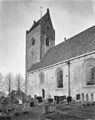
 Kerk vanuit het zuid-oosten - Oudkerk - 20180277 - RCE.jpg 862 × 1,200; 260 KB
-

-

-

-

-
 Noord-oost gevel - Oudkerk - 20180286 - RCE.jpg 1,200 × 956; 240 KB
-
 Noord-oost gevel - Oudkerk - 20180308 - RCE.jpg 1,200 × 948; 194 KB
-
 Oostgevel - Oudkerk - 20180309 - RCE.jpg 951 × 1,200; 195 KB
-
 Oudkerk, de Pauluskerk RM35669 IMG 7639 2020-09-20 11.55.jpg 4,751 × 3,207; 8.68 MB
-

-
-
 Overzicht van de westgevel, tijdens restauratie - Oentsjerk - 20427402 - RCE.jpg 800 × 1,200; 187 KB
-

-
 Pauluskerk van Oudkerk.jpg 2,208 × 1,756; 405 KB
-
 Zuid-oost gevel - Oudkerk - 20180285 - RCE.jpg 1,200 × 957; 287 KB
-
 Zuid-oost zijde - Oudkerk - 20180310 - RCE.jpg 1,200 × 951; 237 KB
-
 Zuid-oostelijke gevel - Oudkerk - 20180311 - RCE.jpg 1,200 × 948; 246 KB
-
 Zuid-west gevel - Oudkerk - 20180312 - RCE.jpg 961 × 1,200; 250 KB
-
 Zuidgevel - Oudkerk - 20180313 - RCE.jpg 1,200 × 949; 292 KB


.jpg)


.jpg)


