Category:Perris maps of Manhattan published 1852–1853
Jump to navigation
Jump to search
Maps from: Perris, William. Maps of the City of New-York in seven volumes, each composed of section maps and title page with volume index (all double-page plates).
- Volume 1, comprising the 1st, 2nd, 3rd, and 4th Ward. (1852), 12 section maps.
- Volume 2, comprising the 7th, 10th, & 13th Ward. (1852), 12 section maps.
- Volume 3, comprising the 5th, 6th, 8th, & 14th Ward. (1853), 14 section maps.
Online at The New York Public Library Digital Collections website, Maps of the city of New York [1852–1854].
Media in category "Perris maps of Manhattan published 1852–1853"
The following 47 files are in this category, out of 47 total.
-
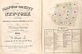
 Volume 1 Index Map.) NYPL1270028.tiff 6,299 × 4,976; 89.7 MB
-
 Volume 2 Index Map.) NYPL1269995.tiff 6,299 × 4,936; 88.97 MB
-
 Volume 3 Index Map.) NYPL1269996.tiff 6,299 × 4,936; 88.97 MB
-
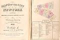 Perris Manhattan V. 1 title page and volume key publ. 1852.jpg 5,750 × 3,851; 4.43 MB
-
 Perris Manhattan V. 2 title page and volume key publ. 1852.jpg 5,906 × 3,811; 5.27 MB
-
 Perris Manhattan V. 3 title page and volume key publ. 1853.jpg 5,836 × 3,902; 4.92 MB
-
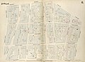
 Perris Manhattan V. 1 Plate 01 publ. 1852.jpg 6,059 × 4,374; 4.73 MB
-
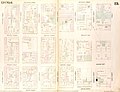
 Perris Manhattan V. 1 Plate 02 publ. 1852.jpg 6,039 × 4,448; 4.76 MB
-
 Perris Manhattan V. 1 Plate 03 publ. 1852.jpg 5,912 × 4,207; 4.18 MB
-
 Perris Manhattan V. 1 Plate 04 publ. 1852.jpg 6,018 × 4,379; 5.01 MB
-
 Perris Manhattan V. 1 Plate 05 publ. 1852.jpg 5,826 × 4,459; 6.25 MB
-
 Perris Manhattan V. 1 Plate 06 publ. 1852.jpg 5,859 × 4,268; 6.34 MB
-
 Perris Manhattan V. 1 Plate 07 publ. 1852.jpg 5,876 × 4,240; 5.62 MB
-
 Perris Manhattan V. 1 Plate 08 publ. 1852.jpg 5,883 × 4,273; 5.4 MB
-
 Perris Manhattan V. 1 Plate 09 publ. 1852.jpg 5,814 × 4,256; 4.18 MB
-
 Perris Manhattan V. 1 Plate 10 publ. 1852.jpg 5,985 × 4,277; 4.98 MB
-
 Perris Manhattan V. 1 Plate 11 publ. 1852.jpg 5,916 × 4,264; 4.08 MB
-
 Perris Manhattan V. 1 Plate 12 publ. 1852.jpg 6,009 × 4,226; 4.78 MB
-
 Perris Manhattan V. 2 Plate 13 publ. 1852.jpg 5,878 × 4,175; 4.84 MB
-
 Perris Manhattan V. 2 Plate 14 publ. 1852.jpg 5,845 × 4,224; 6.17 MB
-
 Perris Manhattan V. 2 Plate 15 publ. 1852.jpg 5,981 × 4,265; 6.91 MB
-
 Perris Manhattan V. 2 Plate 16 publ. 1852.jpg 5,789 × 4,227; 4.85 MB
-
 Perris Manhattan V. 2 Plate 17 publ. 1852.jpg 6,299 × 4,392; 5.58 MB
-
 Perris Manhattan V. 2 Plate 18 publ. 1852.jpg 5,809 × 4,322; 3.75 MB
-
 Perris Manhattan V. 2 Plate 19 publ. 1852.jpg 5,745 × 4,391; 4.99 MB
-
 Perris Manhattan V. 2 Plate 20 publ. 1852.jpg 5,850 × 4,447; 4.46 MB
-
 Perris Manhattan V. 2 Plate 21 publ. 1852.jpg 6,078 × 4,436; 5.61 MB
-
 Perris Manhattan V. 2 Plate 22 publ. 1852.jpg 6,012 × 4,277; 4.21 MB
-
 Perris Manhattan V. 2 Plate 23 publ. 1852.jpg 6,126 × 4,099; 4.73 MB
-
 Perris Manhattan V. 2 Plate 24 publ. 1852.jpg 5,618 × 4,265; 4.13 MB
-
 Perris Manhattan V. 3 Plate 25 publ. 1853 (crop 1).jpg 4,095 × 3,466; 16.99 MB
-
 Perris Manhattan V. 3 Plate 25 publ. 1853 (crop 2).jpg 469 × 336; 51 KB
-
 Perris Manhattan V. 3 Plate 25 publ. 1853 (crop 3).jpg 2,045 × 1,583; 550 KB
-
 Perris Manhattan V. 3 Plate 25 publ. 1853.jpg 6,117 × 4,436; 5.55 MB
-
 Perris Manhattan V. 3 Plate 26 publ. 1853.jpg 6,179 × 4,395; 5.53 MB
-
 Perris Manhattan V. 3 Plate 27 publ. 1853.jpg 6,100 × 4,320; 5.01 MB
-
 Perris Manhattan V. 3 Plate 28 publ. 1853.jpg 6,160 × 4,290; 5.31 MB
-
 Perris Manhattan V. 3 Plate 29 publ. 1853.jpg 6,013 × 4,400; 5.84 MB
-
 Perris Manhattan V. 3 Plate 30 publ. 1853.jpg 6,036 × 4,004; 5.69 MB
-
 Perris Manhattan V. 3 Plate 31 publ. 1853.jpg 5,875 × 4,186; 3.85 MB
-
 Perris Manhattan V. 3 Plate 32 publ. 1853.jpg 6,048 × 4,279; 4.73 MB
-
 Perris Manhattan V. 3 Plate 33 publ. 1853.jpg 5,941 × 4,249; 5.73 MB
-
 Perris Manhattan V. 3 Plate 34 publ. 1853.jpg 6,082 × 4,375; 5.88 MB
-
 Perris Manhattan V. 3 Plate 35 publ. 1853.jpg 6,079 × 4,047; 4.54 MB
-
 Perris Manhattan V. 3 Plate 36 publ. 1853.jpg 5,871 × 4,323; 4.58 MB
-
 Perris Manhattan V. 3 Plate 37 publ. 1853.jpg 5,798 × 4,229; 4.31 MB
-
 Perris Manhattan V. 3 Plate 38 publ. 1853.jpg 6,025 × 4,080; 4.53 MB


.jpg)
.jpg)
.jpg)


