Category:Petruskerk (Garyp)
Jump to navigation
Jump to search
| Object location | | View all coordinates using: OpenStreetMap |
|---|
church building in Tytsjerksteradiel, Netherlands  | |||||
| Upload media | |||||
| Instance of | |||||
|---|---|---|---|---|---|
| Dedicated to | |||||
| Location | Garyp, Tytsjerksteradiel, Friesland, Netherlands | ||||
| Street address |
| ||||
| Located on street |
| ||||
| Heritage designation |
| ||||
| Inception |
| ||||
| official website | |||||
 | |||||
|
This is a category about rijksmonument number 35650
|
| Address |
|
Media in category "Petruskerk (Garyp)"
The following 13 files are in this category, out of 13 total.
-
 De kerk van Garijp, Friesland.jpg 2,472 × 3,024; 1.14 MB
-
 Exterieur - Garijp - 20075022 - RCE.jpg 962 × 1,200; 261 KB
-
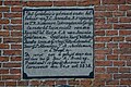
 Fragment priestersteen - Garijp - 20326272 - RCE.jpg 899 × 1,200; 213 KB
-
 Garyp - Petrustsjerke.jpg 4,764 × 3,402; 5.91 MB
-
 Garyp, Petrustsjerke, gevelstien.jpg 6,000 × 4,000; 9.67 MB
-
 Garyp, Petrustsjerke.jpg 4,773 × 3,412; 7.22 MB
-
 Gesmeed ijzeren hekken op het kerkhof - Garijp - 20326271 - RCE.jpg 1,200 × 890; 241 KB
-
 Interieur - Garijp - 20075023 - RCE.jpg 959 × 1,200; 222 KB
-
 Interieur - Garijp - 20075024 - RCE.jpg 1,200 × 955; 194 KB
-
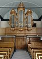 Interieur, aanzicht orgel, orgelnummer 474 - Garyp - 20417097 - RCE.jpg 861 × 1,200; 192 KB
-
 Kerk Tsjerkepead 18 Garijp.JPG 4,608 × 3,456; 1.72 MB
-
 Petruskerk. Hervormde kerk Garijp.jpg 1,944 × 2,592; 628 KB
-
 Priestersteen - Garijp - 20075037 - RCE.jpg 882 × 1,200; 267 KB


