Category:Pfarrhaus (Kirchstrasse 8, Bolligen)
Jump to navigation
Jump to search
| Object location | | View all coordinates using: OpenStreetMap |
|---|
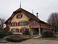
church building in Bolligen in the canton of Bern, Switzerland  | |||||
| Upload media | |||||
| Instance of | |||||
|---|---|---|---|---|---|
| Part of | |||||
| Location | Downtown Bolligen, Bolligen, Bern-Mittelland administrative district, Bernese Mittelland administrative region, Bern, Switzerland | ||||
| Street address |
| ||||
| Heritage designation |
| ||||
| Inception |
| ||||
| Significant event |
| ||||
 | |||||
Media in category "Pfarrhaus (Kirchstrasse 8, Bolligen)"
The following 3 files are in this category, out of 3 total.
-
 CH-NB - Bolligen, Pfarrhaus und Kirche - Collection Gugelmann - GS-GUGE-WEIBEL-D-19a.tif 5,700 × 3,904, 2 pages; 34.2 MB
-
 CH-NB - Bolligen, Pfarrhaus und Kirche - Collection Gugelmann - GS-GUGE-WEIBEL-D-19b.tif 5,700 × 3,866, 2 pages; 37.55 MB
-
 Pfarrhaus Kirchstrasse 8 Bolligen.jpg 2,049 × 1,569; 1.07 MB