Category:Pfarrhaus Oberkirch (Oberkirch 1, Nunningen)
Jump to navigation
Jump to search
| Object location | | View all coordinates using: OpenStreetMap |
|---|
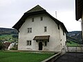
church residential building in Nunningen in the canton of Solothurn, Switzerland  | |||||
| Upload media | |||||
| Instance of | |||||
|---|---|---|---|---|---|
| Part of | |||||
| Location | Nunningen, Thierstein District, Dorneck-Thierstein, Solothurn, Switzerland | ||||
| Street address |
| ||||
| Heritage designation | |||||
 | |||||
Media in category "Pfarrhaus Oberkirch (Oberkirch 1, Nunningen)"
The following 3 files are in this category, out of 3 total.
-
 Nunningen Pfarrhaus.jpg 2,048 × 1,536; 1.51 MB
-
 Oberkirch SO Pfarrhaus 02.JPG 2,816 × 2,112; 1.53 MB
-
 Oberkirch SO Pfarrhaus 03.JPG 2,816 × 2,112; 1.14 MB

