Category:Pfarrhof Kindberg
Jump to navigation
Jump to search
| Object location | | View all coordinates using: OpenStreetMap |
|---|
 | |||||
| Upload media | |||||
| Instance of | |||||
|---|---|---|---|---|---|
| Location | Kindberg, Bruck-Mürzzuschlag District, Styria, Austria | ||||
| Street address |
| ||||
| Heritage designation | |||||
 | |||||
Deutsch: Pfarrhof in Kindberg/Österreich.
Media in category "Pfarrhof Kindberg"
The following 3 files are in this category, out of 3 total.
-
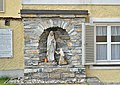 Pfarrhof Kindberg - Lourdes grotto.jpg 4,400 × 3,124; 6.41 MB
-
 Pfarrhof Kindberg 01.jpg 4,609 × 3,123; 7.26 MB
-
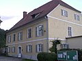 Pfarrhof Kindberg.jpg 1,280 × 960; 191 KB

