Category:Pfarrkirche St. Peter und Paul (Hauptstrasse 1, Düdingen)
Jump to navigation
Jump to search
| Object location | | View all coordinates using: OpenStreetMap |
|---|
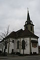
church building in Düdingen in the canton of Fribourg, Switzerland  | |||||
| Upload media | |||||
| Instance of | |||||
|---|---|---|---|---|---|
| Part of | |||||
| Location | Düdingen, Sense District, Canton of Fribourg, Switzerland | ||||
| Street address |
| ||||
| Diocese | |||||
| Heritage designation | |||||
 | |||||
Media in category "Pfarrkirche St. Peter und Paul (Hauptstrasse 1, Düdingen)"
The following 3 files are in this category, out of 3 total.
-
 2012-Duedingen-Pfarrkirche.jpg 1,280 × 1,920; 2.19 MB
-
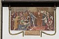 2012-Duedingen-Tagsatzung.jpg 1,920 × 1,280; 2.3 MB
-
 Duedingen FR Kath Kirche.jpg 2,592 × 3,888; 2.86 MB

