Category:Pleshey
Jump to navigation
Jump to search
village in Essex, England, UK  | |||||
| Upload media | |||||
| Instance of | |||||
|---|---|---|---|---|---|
| Location | Chelmsford, Essex, East of England, England | ||||
 | |||||
Subcategories
This category has the following 2 subcategories, out of 2 total.
P
- Holy Trinity Church, Pleshey (4 F)
Media in category "Pleshey"
The following 59 files are in this category, out of 59 total.
-
 A barn conversion at Bury Farm - geograph.org.uk - 788597.jpg 640 × 480; 73 KB
-
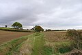
 A byway to Pleshey and Stagden Cross - geograph.org.uk - 788583.jpg 640 × 480; 95 KB
-
 A corner near Pleshey - geograph.org.uk - 401455.jpg 640 × 428; 404 KB
-
 Access Lane leading onto The Street, Pleshey - geograph.org.uk - 5941607.jpg 5,184 × 3,456; 7.69 MB
-
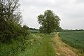
 Bridleway to Pleshey - geograph.org.uk - 785793.jpg 640 × 480; 118 KB
-
 Bury Road passes Bury Farm - geograph.org.uk - 2603228.jpg 640 × 428; 94 KB
-
 Byway by the Gorse - geograph.org.uk - 379306.jpg 640 × 426; 122 KB
-
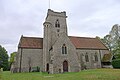 Church of the Holy trinity, Pleshey - geograph.org.uk - 5947028.jpg 3,776 × 2,520; 3.12 MB
-
 Country to the West of Pleshey - geograph.org.uk - 5940529.jpg 5,184 × 3,456; 7.24 MB
-
 Entrance to Pleshey Castle 1984 - geograph.org.uk - 3991515.jpg 800 × 777; 168 KB
-
 Entrance to the bailey of Pleshey Castle - geograph.org.uk - 5947052.jpg 3,776 × 2,520; 3.08 MB
-
 Essex Way above Walthambury Brook - geograph.org.uk - 5941639.jpg 5,184 × 3,456; 7.63 MB
-
 Essex Way East of Pleshey - geograph.org.uk - 5941627.jpg 5,184 × 3,456; 5.37 MB
-
 Farmhouse at Israel's Farm - geograph.org.uk - 399937.jpg 640 × 450; 65 KB
-
 Former White Horse Inn, Pleshey (geograph 5947040).jpg 3,776 × 2,520; 3.18 MB
-
 Holy Trinity Church, Pleshey, Essex - geograph.org.uk - 4647138.jpg 1,024 × 768; 200 KB
-
 Leather Bottle, The Street, Pleshey - geograph.org.uk - 3440825.jpg 3,718 × 3,182; 4.29 MB
-
 Moated entrance to Pleshey Castle - geograph.org.uk - 3991516.jpg 800 × 799; 172 KB
-
 Motte, Pleshey Castle, Essex - geograph.org.uk - 3440826.jpg 4,320 × 3,240; 4.69 MB
-

-
 On the Essex Way to the West of Pleshey - geograph.org.uk - 5941616.jpg 5,184 × 3,456; 6.93 MB
-
 On the Essex Way, E of Pleshey Bridge, Essex - geograph.org.uk - 4647149.jpg 1,024 × 768; 230 KB
-

-
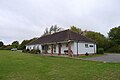 Pleshey Village Hall - geograph.org.uk - 5946998.jpg 3,776 × 2,520; 3.29 MB
-
 Pleshey's village hall - geograph.org.uk - 785769.jpg 640 × 429; 51 KB
-
 Primroses - geograph.org.uk - 379406.jpg 640 × 426; 106 KB
-
 Public right of way - geograph.org.uk - 2603302.jpg 640 × 480; 102 KB
-
 Reservoir near Walthambury Farm - geograph.org.uk - 5947079.jpg 3,776 × 2,520; 3.06 MB
-
 The Essex Way 49 - geograph.org.uk - 1902845.jpg 640 × 426; 108 KB
-

-
 The Essex Way 51 - geograph.org.uk - 1903022.jpg 640 × 426; 78 KB
-
 The Essex Way 52 - geograph.org.uk - 1903034.jpg 640 × 426; 99 KB
-
 The Essex Way 53 - geograph.org.uk - 1903041.jpg 640 × 426; 75 KB
-
 The Essex Way 54 - geograph.org.uk - 1903046.jpg 640 × 426; 124 KB
-
 The Essex Way alongside Waltambury Brook - geograph.org.uk - 5947068.jpg 3,776 × 2,520; 3.2 MB
-
 The Essex Way at Woods Farm - geograph.org.uk - 5940512.jpg 5,184 × 3,456; 7.52 MB
-
 The Holy Trinity Church, Pleshey - geograph.org.uk - 5941596.jpg 5,184 × 3,456; 6.33 MB
-
 The Street Pleshey - geograph.org.uk - 4205440.jpg 4,320 × 3,240; 3.75 MB
-
 The Street, Pleshey (1) - geograph.org.uk - 5941575.jpg 5,184 × 3,456; 7.11 MB
-
 The Street, Pleshey (2) - geograph.org.uk - 5941582.jpg 5,184 × 3,456; 4.68 MB
-
 The Street, Pleshey, Essex - geograph.org.uk - 4647142.jpg 1,024 × 768; 185 KB
-
 All roads lead to Pleshey - geograph.org.uk - 108697.jpg 640 × 480; 146 KB
-
 Arable farmland west of Pleshey - geograph.org.uk - 453472.jpg 640 × 480; 65 KB
-
 Bridleway and track to Oak Hall - geograph.org.uk - 399977.jpg 640 × 480; 115 KB
-
 Bridleway from Pleshey to Fanner's Green - geograph.org.uk - 400675.jpg 640 × 428; 458 KB
-
 Bridleway to Chignall Smealy - geograph.org.uk - 400648.jpg 640 × 428; 325 KB
-
 Catkins by the Byway - geograph.org.uk - 379472.jpg 640 × 426; 90 KB
-
 Farmhouse at Fridays Farm - geograph.org.uk - 287558.jpg 640 × 461; 76 KB
-
 Footpath to Pleshey - geograph.org.uk - 400662.jpg 640 × 428; 321 KB
-
 Israel's Farm - geograph.org.uk - 400829.jpg 640 × 428; 260 KB
-
 Linsteads near Pleshey - geograph.org.uk - 108672.jpg 640 × 480; 86 KB
-
 Lovely Essex - geograph.org.uk - 88942.jpg 640 × 480; 59 KB
-
 Pleshey Grange, Pleshey, Essex - geograph.org.uk - 108702.jpg 640 × 480; 204 KB
-
 Pleshey, Essex - geograph.org.uk - 108690.jpg 640 × 480; 96 KB
-
 Public Bridleway - geograph.org.uk - 287565.jpg 640 × 480; 107 KB
-
 Pussywillow (Not^) - geograph.org.uk - 379432.jpg 640 × 426; 117 KB
-
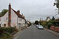
 The Street, Pleshey, Essex - geograph.org.uk - 108682.jpg 640 × 480; 126 KB
-
 The White Horse, Pleshey - geograph.org.uk - 100203.jpg 640 × 436; 123 KB
-
 Wart Cottages - geograph.org.uk - 400950.jpg 640 × 428; 127 KB


.jpg)


_-_geograph.org.uk_-_5941575.jpg)
_-_geograph.org.uk_-_5941582.jpg)


_-_geograph.org.uk_-_379432.jpg)


