Category:Pletes de les Pallargues
Jump to navigation
Jump to search
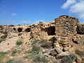
Català: Pletes de les Pallargues (els Plans de Sió)
This is a category about a building listed in the Catalan heritage register as Bé Cultural d'Interès Local (BCIL) under the reference IPA-35676. |
|
This is a category with photos about a natural area in Catalonia, Spain, with id: ES510216
|
| Object location | | View all coordinates using: OpenStreetMap |
|---|
 | |||||
| Upload media | |||||
| Instance of |
| ||||
|---|---|---|---|---|---|
| Located in protected area | |||||
| Location | Mont-roig, Els Plans de Sió, Segarra, Ponent, Province of Lleida, Catalonia | ||||
| Street address |
| ||||
| Architectural style | |||||
| Heritage designation |
| ||||
| Inception |
| ||||
| Elevation above sea level |
| ||||
 | |||||
Media in category "Pletes de les Pallargues"
The following 7 files are in this category, out of 7 total.
-
 Plans de Sió - 4.jpg 4,608 × 3,072; 6.41 MB
-
 PLETES DE LES PALLARGUES - IB-079.JPG 2,048 × 1,536; 1.01 MB
-
 PLETES DE LES PALLARGUES - IB-747.JPG 2,048 × 1,536; 1.44 MB
-
 PLETES DE LES PALLARGUES - IB-748.JPG 2,048 × 1,536; 1.48 MB
-
 PLETES DE LES PALLARGUES - IB-750.JPG 2,048 × 1,536; 1.44 MB
-
 PLETES DE LES PALLARGUES - IB-751.JPG 2,048 × 1,536; 1.39 MB
-
 Pletes Montroig i de les Pallargues, la Segarra, Lleida.jpg 6,000 × 4,000; 5.69 MB


