Category:Point Stephens Lighthouse
Jump to navigation
Jump to search
| Object location | | View all coordinates using: OpenStreetMap |
|---|
lighthouse in New South Wales, Australia  | |||||
| Upload media | |||||
| Instance of | |||||
|---|---|---|---|---|---|
| Made from material | |||||
| Location | Point Stephens, New South Wales, AUS | ||||
| Operator | |||||
| Heritage designation |
| ||||
| Inception |
| ||||
| Significant event |
| ||||
| Source of energy | |||||
| Height |
| ||||
 | |||||
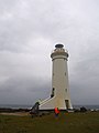
English: Point Stephens Light is a heritage-listed active lighthouse located on Point Stephens, a point on an unnamed headland at the east of Fingal Bay, 4.25 km (2.64 mi) south of the entrance of Port Stephens, New South Wales, Australia.
Media in category "Point Stephens Lighthouse"
The following 12 files are in this category, out of 12 total.
-
 Point Stephens Light - spiral stairway.jpg 800 × 600; 103 KB
-
 Point Stephens Light, 1902 cropped.jpg 761 × 923; 232 KB
-
 Point Stephens Light, 1902.jpg 784 × 1,050; 218 KB
-
 Point Stephens Light, handrail for lantern platform, 1932.jpg 1,726 × 2,953; 472 KB
-
 Point Stephens Light, new handrail to tower steps plan, 1903.jpg 2,057 × 2,953; 201 KB
-
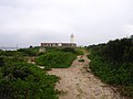 Point Stephens lighthouse approach.jpg 800 × 600; 70 KB
-
 Point Stephens Lighthouse cropped.jpg 1,614 × 2,199; 692 KB
-
 Point Stephens Lighthouse keepers quarters.jpg 800 × 600; 70 KB
-
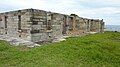 Point Stephens Lighthouse ruins.jpg 3,968 × 2,232; 4.18 MB
-
 Point Stephens Lighthouse, 2006.jpg 600 × 800; 46 KB
-
 Point Stephens Lighthouse.jpg 3,968 × 2,232; 2.86 MB
-
 Port Stephens Light 1917.jpg 312 × 425; 41 KB


Categories:
- Lighthouses in New South Wales
- Lighthouses in Australia by name
- Lighthouses built in 1862
- Lighthouses by height, 21 to 30 meters
- Stone lighthouses
- Tomaree National Park
- Solar-powered lighthouses
- Fingal Bay, New South Wales
- New South Wales State Heritage Register
- Lighthouses by range, 15 to 19 nm
- Landfall lights