Category:Political maps of Highland County, Ohio as of the 2000 United States Census
Jump to navigation
Jump to search
Media in category "Political maps of Highland County, Ohio as of the 2000 United States Census"
The following 27 files are in this category, out of 27 total.
-
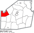
 Map of Highland County Ohio Highlighting Brushcreek Township.png 590 × 568; 29 KB
-
 Map of Highland County Ohio Highlighting Clay Township.png 590 × 568; 29 KB
-
 Map of Highland County Ohio Highlighting Concord Township.png 590 × 568; 29 KB
-
 Map of Highland County Ohio Highlighting Dodson Township.png 590 × 568; 28 KB
-
 Map of Highland County Ohio Highlighting Fairfield Township.png 590 × 568; 29 KB
-
 Map of Highland County Ohio Highlighting Greenfield Village.png 590 × 568; 28 KB
-
 Map of Highland County Ohio Highlighting Hamer Township.png 590 × 568; 28 KB
-
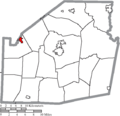
 Map of Highland County Ohio Highlighting Highland Village.png 590 × 568; 28 KB
-
 Map of Highland County Ohio Highlighting Hillsboro City.png 590 × 568; 28 KB
-
 Map of Highland County Ohio Highlighting Jackson Township.png 590 × 568; 29 KB
-
 Map of Highland County Ohio Highlighting Leesburg Village.png 590 × 568; 28 KB
-
 Map of Highland County Ohio Highlighting Liberty Township.png 590 × 568; 29 KB
-
 Map of Highland County Ohio Highlighting Lynchburg Village.png 590 × 568; 28 KB
-
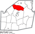
 Map of Highland County Ohio Highlighting Madison Township.png 590 × 568; 29 KB
-
 Map of Highland County Ohio Highlighting Marshall Township.png 590 × 568; 28 KB
-
 Map of Highland County Ohio Highlighting Mowrystown Village.png 590 × 568; 28 KB
-
 Map of Highland County Ohio Highlighting New Market Township.png 590 × 568; 28 KB
-
 Map of Highland County Ohio Highlighting Paint Township.png 590 × 568; 29 KB
-
 Map of Highland County Ohio Highlighting Penn Township.png 590 × 568; 28 KB
-
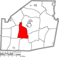
 Map of Highland County Ohio Highlighting Salem Township.png 590 × 568; 28 KB
-
 Map of Highland County Ohio Highlighting Sinking Spring Village.png 590 × 568; 28 KB
-
 Map of Highland County Ohio Highlighting Union Township.png 590 × 568; 29 KB
-
 Map of Highland County Ohio Highlighting Washington Township.png 590 × 568; 28 KB
-
 Map of Highland County Ohio Highlighting Whiteoak Township.png 590 × 568; 29 KB
-
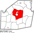
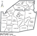 Map of Highland County Ohio With Municipal and Township Labels.PNG 590 × 568; 46 KB
-
 Map of Highland County, Ohio No Text, Municipalities Distinct.png 590 × 568; 28 KB
-
 Map of Highland County, Ohio No Text.png 590 × 568; 28 KB


