Category:Pomp Tolstraat, Zaltbommel
Jump to navigation
Jump to search
| Object location | | View all coordinates using: OpenStreetMap |
|---|
 | |||||
| Upload media | |||||
| Instance of | |||||
|---|---|---|---|---|---|
| Location | Zaltbommel, Gelderland, Netherlands | ||||
| Street address |
| ||||
| Heritage designation |
| ||||
 | |||||
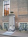
Nederlands: Hardstenen pomp an de Tolstraat
|
This is a category about rijksmonument number 40263
|
| Address |
|
Media in category "Pomp Tolstraat, Zaltbommel"
The following 3 files are in this category, out of 3 total.
-
 Pomp bij Raadhuis, aanzicht - Zaltbommel - 20219632 - RCE.jpg 800 × 1,200; 268 KB
-
 Tolstraat Hardstenen pomp.jpg 3,000 × 4,000; 1,010 KB
-
 Waterpomp Markt Zaltbommel Nederland.JPG 1,944 × 2,592; 2.34 MB

