Category:Pomp op de Markt, Tiel
Jump to navigation
Jump to search
| Object location | | View all coordinates using: OpenStreetMap |
|---|
.JPG) | |||||
| Upload media | |||||
| Instance of | |||||
|---|---|---|---|---|---|
| Location | Tiel, Gelderland, Netherlands | ||||
| Street address |
| ||||
| Heritage designation |
| ||||
 | |||||
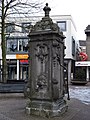
Nederlands: Pomp op de Markt
|
This is a category about rijksmonument number 35564
|
| Address |
|
Media in category "Pomp op de Markt, Tiel"
The following 4 files are in this category, out of 4 total.
-
 Pomp op de Markt - Tiel - 20208734 - RCE.jpg 885 × 1,200; 208 KB
-
 Tiel Water Pump (Markt).JPG 1,944 × 2,592; 2.23 MB
-
 Waterpomp Tiel 1306 - 003.jpg 3,648 × 2,736; 2.55 MB
-
 Zicht op pomp met lantaarn op de Markt - Tiel - 20208733 - RCE.jpg 896 × 1,200; 250 KB


