Category:Ponors
Jump to navigation
Jump to search
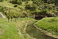
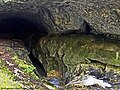
Deutsch: Ein Ponor (Südslawisch), auch Schluckloch, sinkhole, Schwalgloch oder katavothra (καταβόθρα) ist eine Stelle, an der ein Gewässer (fließendes- oder stehendes Gewässer) bei entsprechendem Wasserstand die Öffnung erreicht und – je nach Durchflusskapazität – ganz oder teilweise abfließt und unterirdisch weiterfließt.
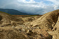
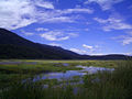
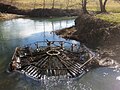
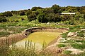
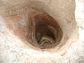
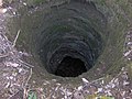
English: A Ponor is a kind of sinkhole with a loss of a stream or part of it that disappears underground (may be seasonal), due to karstic geology.
Français : Un ponor est un orifice naturel situé au fond d'un poljé par lequel une eau de surface (cours d'eau ou eau de pluie) disparaît et devient souterraine.
Ελληνικά: Καταβόθρα
karstic cave formation that drains into a subterranean water system  | |||||
| Upload media | |||||
| Subclass of | |||||
|---|---|---|---|---|---|
| Different from | |||||
| |||||
Subcategories
This category has the following 3 subcategories, out of 3 total.
Media in category "Ponors"
The following 40 files are in this category, out of 40 total.
-
 AlapahaRiver2002.jpg 2,010 × 1,507; 641 KB
-
 Allt Smoo falling into the cave, Durness - geograph.org.uk - 3990264.jpg 1,024 × 678; 306 KB
-
 Artlish River Cave.jpg 438 × 648; 85 KB
-
 Avenul campeneasca.jpg 2,048 × 1,536; 2.07 MB
-
 Bıyıklı Düden 20 05 1998 Abfluss-Ponor der Kırkgöz-Quellen.jpg 2,681 × 1,725; 2.57 MB
-
 Carte hydrogeologique nord gramat.png 1,188 × 771; 58 KB
-
 Cavone, Spinazzola - 6 May 2017.jpg 2,340 × 4,160; 5.46 MB
-
 Cerknisko jezero .jpg 3,008 × 2,000; 3.97 MB
-
 Cerkniško jezero-3.JPG 900 × 600; 211 KB
-
 Cerkniško jezero.jpg 1,600 × 1,200; 283 KB
-
 Engolidor al riu Gorgos.JPG 4,608 × 3,072; 2.13 MB
-
 ForauAigualluts 2.jpg 320 × 240; 37 KB
-
 GapingGillSurface.jpg 1,152 × 864; 229 KB
-
 Gouffre de Belvaux Luc Viatour.JPG 2,000 × 2,816; 5.77 MB
-
 Grutas da nascente do Alviela (1).JPG 1,600 × 1,200; 290 KB
-
 Grutas da nascente do Alviela (3).JPG 1,600 × 1,200; 278 KB
-
 Grutas da nascente do Rio Alviela.JPG 1,600 × 1,200; 250 KB
-
 Jakovica, Logatec - požiralnik Pod stenami na Planinskem polju.jpg 2,048 × 1,536; 550 KB
-
 KARAGÖL DÜDEN.jpg 3,872 × 2,592; 10.59 MB
-
 Katavothra ponor Nestani-Polje Peloponnes Greece.jpg 1,800 × 1,200; 2.81 MB
-
 Katavothra ponor Tripoli-Polje Taka Plain Peloponnese Greece.jpg 1,200 × 1,800; 2.36 MB
-
 Katavothra Taka-plain Tripoli-Polje Peloponnese Greece.jpg 1,800 × 1,200; 2.88 MB
-
 Katavothra-Kapsia ponor Tripoli-Polje Peloponnes Greece.jpg 2,000 × 1,200; 2.2 MB
-
 Kraski Poziralnik.jpg 1,200 × 1,600; 520 KB
-
 Krottenbach Bachschwinde.JPG 3,622 × 2,418; 5.45 MB
-
 Limestone Hole.JPG 640 × 480; 179 KB
-
 Miniaturni ponor, Plitvicka jezera.jpg 640 × 480; 107 KB
-
 Polje-Modell.jpg 1,252 × 678; 497 KB
-
 Pwll Byfre in wet conditions - geograph.org.uk - 1344046.jpg 640 × 480; 122 KB
-
 Riu Gorgos, engolidor.JPG 4,608 × 3,072; 2.3 MB
-
 Sinkhole-col-tn1.jpg 640 × 479; 108 KB
-
 Sinkhole-col-tn2.jpg 2,041 × 1,533; 834 KB
-
 Sinkhole-col-tn3.jpg 2,041 × 1,533; 1.05 MB
-
 SinksofGandyCreek1.jpg 2,816 × 2,112; 1.46 MB
-
 Stream from Langvatnet that disappears into a cave system.jpg 4,896 × 3,264; 9.56 MB
-
 Sumidouro da Ribeira dos Amiais - Portugal (26498565342).jpg 3,264 × 2,448; 2.31 MB
-
 Unterwald-Ponor 02.jpg 5,472 × 3,648; 18 MB
-
 Unterwald-Ponor 03.jpg 5,472 × 3,648; 18.05 MB
-
 Unterwald-Ponor 05.jpg 5,472 × 3,648; 18.45 MB
-
 Unterwald-Ponor 06.jpg 5,472 × 3,648; 19.62 MB


.JPG)
.JPG)


.jpg)


