Category:Pont sur la Dourbie, Nant
Jump to navigation
Jump to search
| Object location | | View all coordinates using: OpenStreetMap |
|---|
|
This building is inscrit au titre des monuments historiques de la France. It is indexed in the base Mérimée, a database of architectural heritage maintained by the French Ministry of Culture, under the reference PA00094091
|
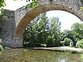
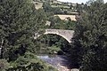
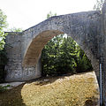
medieval bridge over the Dourbie rive in Nant, France  | |||||
| Upload media | |||||
| Instance of | |||||
|---|---|---|---|---|---|
| Location | Nant, canton of Nant | ||||
| Heritage designation |
| ||||
 | |||||
Media in category "Pont sur la Dourbie, Nant"
The following 7 files are in this category, out of 7 total.
-
 Nant - Pont sur la Dourbie -4.JPG 4,896 × 3,672; 7.85 MB
-
 Nant - Pont sur la Dourbie -5.JPG 3,412 × 4,360; 6.53 MB
-
 Nant - Pont sur la Dourbie -6.JPG 4,896 × 3,672; 7.33 MB
-
 Nant - Pont sur la Dourbie -7.JPG 4,896 × 3,672; 8.28 MB
-
 Nant-La Dourbie-20120624.jpg 4,272 × 2,848; 3.95 MB
-
 Nant-Pont roman VJP-20120624.jpg 4,200 × 2,800; 3.57 MB
-
 Nant-Pont sur la Dourbie VA-20120624.jpg 4,000 × 4,000; 3.93 MB


