Category:Population density maps of Corrèze
Jump to navigation
Jump to search
Departments of Metropolitan France: Calvados [14] · Charente [16] · Charente-Maritime [17] · Cher [18] · Corrèze [19] · Côtes-d'Armor [22] · Creuse [23] · Dordogne [24] · Eure [27] · Eure-et-Loir [28] · Finistère [29] · Gironde [33] · Ille-et-Vilaine [35] · Indre [36] · Indre-et-Loire [37] · Landes [40] · Loir-et-Cher [41] · Loire-Atlantique [44] · Loiret [45] · Maine-et-Loire [49] · Manche [50] · Mayenne [53] · Morbihan [56] · Orne [61] · Pyrénées-Atlantiques [64] · Haut-Rhin [68] · Sarthe [72] · Paris [75] · Seine-Maritime [76] · Deux-Sèvres [79] · Tarn-et-Garonne [82] · Vendée [85] · Vienne [86] · Haute-Vienne [87]
Overseas departments and regions: Guadeloupe [971] · Martinique [972] · Réunion [974]
Overseas departments and regions: Guadeloupe [971] · Martinique [972] · Réunion [974]
Media in category "Population density maps of Corrèze"
The following 8 files are in this category, out of 8 total.
-
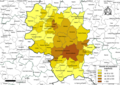 19-Intercos2019-200043172-Densités.png 3,519 × 2,480; 2.31 MB
-
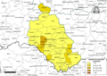
 19-Intercos2019-200066603-Densités.png 3,519 × 2,480; 1.43 MB
-
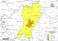
 19-Intercos2019-200066751-Densités.png 3,519 × 2,480; 1.93 MB
-
 19-Intercos2019-200066769-Densités.png 3,519 × 2,480; 2.04 MB
-
 19-Intercos2019-241900133-Densités.png 3,519 × 2,480; 1.8 MB
-
 19-Intercos2019-241927201-Densités.png 3,519 × 2,480; 2.18 MB
-
 19-Intercos2019-241927243-Densités.png 3,519 × 2,480; 1.73 MB
-
 2007 population 19.png 7,490 × 7,490; 3.97 MB


