Category:Port Sunlight Post Office
Jump to navigation
Jump to search
| Object location | | View all coordinates using: OpenStreetMap |
|---|
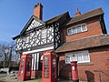
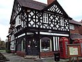
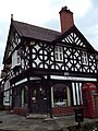
Grade II listed former post office in Port Sunlight, England  | |||||
| Upload media | |||||
| Instance of | |||||
|---|---|---|---|---|---|
| Location | Port Sunlight, Wirral, Merseyside, North West England, England | ||||
| Heritage designation |
| ||||
 | |||||
Grade II listed, originally Port Sunlight's Post Office, explaining the post box and telephone kiosks. Now a tea rooms.
Subcategories
This category has only the following subcategory.
Media in category "Port Sunlight Post Office"
The following 7 files are in this category, out of 7 total.
-
 Post box at Port Sunlight Post Office.jpg 3,144 × 5,022; 7.13 MB
-
 Port Sunlight (25680128516).jpg 4,000 × 3,000; 2.92 MB
-
 Port Sunlight - DSC04549.JPG 3,648 × 2,736; 3.51 MB
-
 Port Sunlight - DSC04550.JPG 2,736 × 3,648; 3.58 MB
-
 Port Sunlight Post Office - geograph.org.uk - 239530.jpg 640 × 480; 108 KB
-
 Port Sunlight Post Office.jpg 4,276 × 3,270; 16.83 MB
-
 Tudor Rose Tea Rooms, Port Sunlight.jpg 1,500 × 965; 192 KB

.jpg)


