Category:Porte Sainte-Catherine (Beaulieu-sur-Dordogne)
Jump to navigation
Jump to search
|
This building is inscrit au titre des monuments historiques de la France. It is indexed in the base Mérimée, a database of architectural heritage maintained by the French Ministry of Culture, under the reference PA00099682
|
| Object location | | View all coordinates using: OpenStreetMap |
|---|
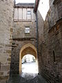
Français : La porte Sainte-Catherine, appelée à tort « porte de la Tour », est située au début de la rue Sainte-Catherine, à l'emplacement des anciens remparts de Beaulieu-sur-Dordogne, Corrèze, France.
.JPG) | |||||
| Upload media | |||||
| Instance of | |||||
|---|---|---|---|---|---|
| Location | |||||
| Street address |
| ||||
| Heritage designation |
| ||||
 | |||||
Media in category "Porte Sainte-Catherine (Beaulieu-sur-Dordogne)"
The following 4 files are in this category, out of 4 total.
-
 Beaulieu-sur-Dordogne porte Ste-Catherine (1).JPG 2,448 × 3,264; 3.76 MB
-
 Beaulieu-sur-Dordogne porte Ste-Catherine (2).JPG 2,448 × 3,264; 3.8 MB
-
 Beaulieu-sur-Dordogne porte Ste-Catherine.JPG 3,264 × 2,448; 3.68 MB
-
 Beaulieu-sur-Dordogne, porte dite de La Tour.jpg 2,953 × 3,937; 3.85 MB
.JPG)

