Category:Pruikmakershoek 10, Makkum
Jump to navigation
Jump to search
| Object location | | View all coordinates using: OpenStreetMap |
|---|
building in Súdwest-Fryslân, Netherlands  | |||||
| Upload media | |||||
| Instance of | |||||
|---|---|---|---|---|---|
| Location | Makkum, Friesland, Netherlands | ||||
| Street address |
| ||||
| Located on street | |||||
| Heritage designation |
| ||||
 | |||||
|
This is a category about rijksmonument number 353636
|
| Address |
|
Media in category "Pruikmakershoek 10, Makkum"
The following 6 files are in this category, out of 6 total.
-
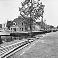
 Bij Waag - Makkum - 20150388 - RCE.jpg 1,200 × 807; 170 KB
-
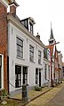
 Gevels - Makkum - 20150390 - RCE.jpg 1,200 × 807; 171 KB
-
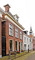
 Pruikmakershoek - Makkum - 20150307 - RCE.jpg 1,200 × 1,185; 352 KB
-
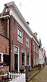
 Pruikmakershoek10 Makkum.jpg 2,064 × 3,408; 508 KB
-
 Pruikmakershoek12 Makkum.jpg 1,848 × 3,216; 529 KB
-
 Pruikmakershoek16 Makkum.jpg 2,056 × 3,552; 725 KB


