Category:Public transport maps of Stockholm County
Jump to navigation
Jump to search
Subcategories
This category has the following 3 subcategories, out of 3 total.
Media in category "Public transport maps of Stockholm County"
The following 9 files are in this category, out of 9 total.
-
 GleisplanRoslagen2021.png 10,597 × 6,823; 1.09 MB
-
 Roslagsbanan.svg 600 × 600; 313 KB
-
 Saltsjöbanan map.svg 600 × 290; 106 KB
-
 Stockholm commuter rail county map.svg 874 × 1,149; 688 KB
-
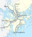 Stockholm commuter rail geographic map.png 1,800 × 2,100; 1.19 MB
-
 Stockholm commuter rail geographic map.svg 600 × 700; 729 KB
-
 Stockholm commuter rail map.svg 800 × 800; 254 KB
-
 U-Stadt-undStraßenbahnGleisplanStockholm2021.png 19,236 × 15,688; 5.08 MB
-
 斯德哥尔摩地铁.jpg 1,284 × 1,206; 437 KB


