Category:Puerto de Playa Santiago
Jump to navigation
Jump to search
| Camera location | | View all coordinates using: OpenStreetMap |
|---|
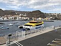
English: Pictures of the harbour of Playa de Santiago, with the ferry terminal and the marina, in Playa de Santiago (Alajeró) in the south of La Gomera. Near to the beach of Playa de Santiago
Nederlands: Afbeeldingen van de haven van Playa de Santiago, met onder meer de veerbootterminal en de jachthaven, in Playa de Santiago (Alajeró) in het zuiden van La Gomera. Gelegen nabij het strand van Playa de Santiago
Media in category "Puerto de Playa Santiago"
The following 7 files are in this category, out of 7 total.
-
 Benchi Express - Playa Santiago(1).jpg 4,032 × 3,024; 2.29 MB
-
 Benchi Express - Playa Santiago(2).jpg 4,032 × 3,024; 3.05 MB
-
 Benchi Express - Playa Santiago(3).jpg 4,032 × 3,024; 2.85 MB
-
 Benchi Express - Playa Santiago(4).jpg 4,032 × 3,024; 2.74 MB
-
 Benchi Express - Playa Santiago.jpg 4,032 × 3,024; 2.51 MB
-
 Playa de Santiago Harbour (8552194803).jpg 5,184 × 3,100; 9.42 MB
-
 Puerto de Playa Santiago port on La Gomera, Spain (48293800967).jpg 3,992 × 2,656; 8.29 MB
.jpg)
.jpg)
.jpg)
.jpg)

.jpg)
.jpg)