Category:Putzbrunn
Jump to navigation
Jump to search
municipality of Germany    | |||||
| Upload media | |||||
| Pronunciation audio | |||||
|---|---|---|---|---|---|
| Instance of |
| ||||
| Part of |
| ||||
| Location | Munich, Upper Bavaria, Bavaria, Germany | ||||
| Head of government |
| ||||
| Population |
| ||||
| Area |
| ||||
| Elevation above sea level |
| ||||
| official website | |||||
 | |||||
Subcategories
This category has the following 8 subcategories, out of 8 total.
Media in category "Putzbrunn"
The following 6 files are in this category, out of 6 total.
-
 DEU Putzbrunn COA.svg 512 × 559; 21 KB
-
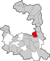
 Putzbrunn - Lage im Landkreis.png 157 × 185; 25 KB
-
 Putzbrunn, Alt St. Stephan (Schuster-Orgel) (13).jpg 3,000 × 4,000; 3.24 MB
-
 Putzbrunn, Busanzeiger, 2.jpeg 4,800 × 3,200; 4.08 MB
-
 Putzbrunnlkrm.svg 593 × 711; 120 KB
-
 Wappen von Putzbrunn.png 255 × 267; 13 KB

_(13).jpg)


