Category:Räbhüsi-Brunnen
Jump to navigation
Jump to search
| Object location | | View all coordinates using: OpenStreetMap |
|---|
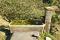
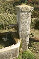
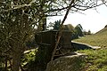
Deutsch: Der Räbhüsi-Brunnen ist ein Brunnen mitten im Abhang hinter Bäumen im Gebiet Räbhüsi 70 Meter nordwestlich des Bauernhofes Gäbelbachweg 51 im Bethlehemquartier in der Stadt Bern in der Schweiz.
 | |||||
| Upload media | |||||
| Instance of | |||||
|---|---|---|---|---|---|
| Part of | |||||
| Made from material | |||||
| Location | Riedern, Bethlehem, Bümpliz-Oberbottigen, Bern, Bern-Mittelland administrative district, Bernese Mittelland administrative region, Bern, Switzerland | ||||
| Street address |
| ||||
| Owned by |
| ||||
| Operator |
| ||||
| Elevation above sea level |
| ||||
 | |||||
Media in category "Räbhüsi-Brunnen"
The following 7 files are in this category, out of 7 total.
-
 Räbhüsi-Brunnen 01.jpg 4,000 × 2,661; 10.82 MB
-
 Räbhüsi-Brunnen 02.jpg 4,200 × 2,795; 11.89 MB
-
 Räbhüsi-Brunnen 03.jpg 4,400 × 2,928; 14.53 MB
-
 Räbhüsi-Brunnen 04.jpg 4,300 × 2,861; 13.47 MB
-
 Räbhüsi-Brunnen 05.jpg 2,929 × 4,400; 13.01 MB
-
 Räbhüsi-Brunnen 06.jpg 4,400 × 2,928; 13.34 MB
-
 Räbhüsi-Brunnen 07.jpg 4,200 × 2,794; 10.68 MB


