Category:Römische Hafenstraße (Köln)
Jump to navigation
Jump to search
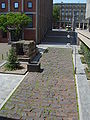
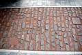
Deutsch: Quellen: kuladig: Abschnitt der römischen Hafenstraße am heutigen Roncalliplatz und Römisch-Germanisches Museum: Hafenstraße und Abwasserkanal
| Object location | | View all coordinates using: OpenStreetMap |
|---|
Media in category "Römische Hafenstraße (Köln)"
The following 7 files are in this category, out of 7 total.
-
 Hafenstrasse-Koeln.jpg 2,112 × 2,816; 2.76 MB
-
 Köln - alten Römerstraße.JPG 3,008 × 2,000; 2.83 MB
-
 Köln, Römische Hafenstraße.jpg 4,896 × 3,672; 6.05 MB
-
 Römische Hafenstraße, Köln-1349.jpg 6,720 × 4,480; 19.57 MB
-
 Römische Hafenstraße, Köln-2319.jpg 6,720 × 4,480; 21.69 MB
-
 Römische Hafenstraße, Köln-2321.jpg 6,720 × 4,480; 20.33 MB
-
 Studiengebäude des Römisch-Germanischen Museums Köln-7092.jpg 5,184 × 3,456; 11.35 MB


