Category:Rùm
Jump to navigation
Jump to search
island in Lochaber, Highland, Scotland, UK, one of the Small Isles of the Inner Hebrides   | |||||
| Upload media | |||||
| Instance of | |||||
|---|---|---|---|---|---|
| Location |
| ||||
| Located in or next to body of water |
| ||||
| Highest point |
| ||||
| Population |
| ||||
| Area |
| ||||
| Different from | |||||
| official website | |||||
 | |||||
Rùm is one of the main islands in the Small Isles archipelago of the Inner Hebrides.
Subcategories
This category has the following 16 subcategories, out of 16 total.
A
- Animals of Rùm (30 F)
B
C
- Cliffs of Rùm (13 F)
- Coasts of Rùm (32 F)
G
L
M
- Maps of Rùm (10 F)
P
- Plants of Rùm (12 F)
R
- Remote views of Rùm (49 F)
- Rubha Shamhnan Insir (4 F)
- Ruins on Rùm (14 F)
S
V
Media in category "Rùm"
The following 119 files are in this category, out of 119 total.
-
 A slightly damp Craig - Flickr - Graham Grinner Lewis.jpg 3,648 × 2,736; 2.5 MB
-
 A Swedish boat from the otter hide - geograph.org.uk - 2952471.jpg 800 × 530; 138 KB
-
 Abandoned house, Port na Caranean, Rum (geograph 2952486).jpg 800 × 530; 141 KB
-
 Achateny Sunset - geograph.org.uk - 464195.jpg 640 × 406; 50 KB
-
 Approaching Rum - geograph.org.uk - 2949629.jpg 800 × 530; 113 KB
-
 Approaching the pier, Rùm - geograph.org.uk - 3768977.jpg 3,000 × 2,046; 1.42 MB
-
 Arrival at Rùm pier - geograph.org.uk - 3776579.jpg 3,000 × 2,250; 1.69 MB
-
 Askival, Hallival and Mullach Ard (geograph 2920782).jpg 640 × 480; 327 KB
-
 Beach at Port-na-Caranean, Rum - geograph.org.uk - 153390.jpg 640 × 480; 109 KB
-
 Between Loch Papadil and the sea - geograph.org.uk - 2947500.jpg 1,200 × 782; 345 KB
-
 Black House at Port-na-Caranean (geograph 2919529).jpg 640 × 460; 492 KB
-
 Black House at Port-na-Caranean (geograph 2920683).jpg 640 × 480; 503 KB
-
 Black House Ruins (geograph 2919555).jpg 640 × 468; 472 KB
-
 Black Houses (geograph 2919540).jpg 640 × 394; 419 KB
-
 Boulder Beach (geograph 2920716).jpg 640 × 472; 420 KB
-
 Bridge at Kinloch Castle (geograph 3130847).jpg 720 × 1,080; 534 KB
-
 Bridge over diverted burn - geograph.org.uk - 996968.jpg 640 × 480; 82 KB
-
 Bridge over the Kilmory River - geograph.org.uk - 996972.jpg 640 × 480; 96 KB
-
 Bàgh Rubha Mhoil Ruaidh - geograph.org.uk - 818447.jpg 640 × 480; 71 KB
-
 Camas Pliasgaig - geograph.org.uk - 818724.jpg 640 × 480; 83 KB
-
 Camas Sgiotaig and the Rum Mountains - geograph.org.uk - 4330612.jpg 699 × 800; 84 KB
-
 Camping cabins at Kinloch (geograph 4567205).jpg 640 × 480; 480 KB
-
 Canna and Sanday from Kilmory, Rum - geograph.org.uk - 1438062.jpg 640 × 335; 76 KB
-
 Cattle on Cleadale Beach - geograph.org.uk - 842910.jpg 640 × 360; 35 KB
-
 Cave at Bagh na h-Uamha - geograph.org.uk - 29670.jpg 640 × 480; 125 KB
-
 Coast of Rum at Aite Suidh' an Easbuig - geograph.org.uk - 6189757.jpg 1,024 × 769; 135 KB
-
 Coast of Rum north of Loch Scresort - geograph.org.uk - 6188832.jpg 1,024 × 768; 89 KB
-
 Coastal track with view of Eigg - geograph.org.uk - 791254.jpg 500 × 375; 30 KB
-
 Corrie Dubh - geograph.org.uk - 2506555.jpg 800 × 531; 79 KB
-
 Cro nan Laogh (geograph 2920701).jpg 640 × 471; 455 KB
-
 Down the Dibidil path (geograph 5089478).jpg 2,821 × 2,000; 2.27 MB
-
 Drochaid Sheorais, by Kinloch Castle (geograph 3767315).jpg 2,400 × 2,400; 1.64 MB
-
 Eastern Layered Intrusion - geograph.org.uk - 2506569.jpg 800 × 531; 103 KB
-
 Eigg - On An Sgurr looking towards Rum - geograph.org.uk - 5612751.jpg 5,184 × 2,920; 4.74 MB
-
 Eigg and Rum from the ferry - geograph.org.uk - 2201286.jpg 640 × 399; 209 KB
-
 Erratic - geograph.org.uk - 151116.jpg 640 × 480; 97 KB
-
 Farewell to Rum - geograph.org.uk - 2952534.jpg 800 × 530; 115 KB
-
 Ferry pier and slip, Isle of Rum - geograph.org.uk - 6188829.jpg 1,024 × 768; 145 KB
-
 Fire and rescue service, Isle of Rum (geograph 4567181).jpg 640 × 480; 439 KB
-
 Footpath from Kinloch to Port-na-Caranean - geograph.org.uk - 151109.jpg 480 × 640; 145 KB
-
 Geo at Samhnan Insir - geograph.org.uk - 998897.jpg 640 × 480; 81 KB
-
 Inlet near the head of Loch Scresort (geograph 4567208).jpg 640 × 480; 425 KB
-
 Isle of Rum Community Hall and General Store in Kinloch (geograph 4965120).jpg 4,000 × 3,000; 3.09 MB
-
 Isle of Rum new pier - geograph.org.uk - 2999312.jpg 640 × 424; 253 KB
-
 Isle of Rum new pier - geograph.org.uk - 3002399.jpg 640 × 424; 241 KB
-
 Isle of Rum new pier - geograph.org.uk - 3003490.jpg 640 × 424; 188 KB
-
 Isle of Rùm - geograph.org.uk - 2914526.jpg 640 × 479; 310 KB
-
 Killing the moss - Rum ferry slipway - geograph.org.uk - 3483738.jpg 637 × 1,024; 489 KB
-
 Kinloch and Kinloch Glen (geograph 2221672).jpg 2,560 × 1,920; 1.07 MB
-
 Kinloch Church Pulpit (geograph 2506608).jpg 800 × 531; 92 KB
-
 Kinloch Hostel (geograph 3767210).jpg 3,000 × 2,024; 1.6 MB
-
 Kinloch Hostel (geograph 4567057).jpg 640 × 480; 475 KB
-
 Lava - geograph.org.uk - 411161.jpg 640 × 427; 303 KB
-
 Loch Scresort - Isle of Rum (geograph 3002439).jpg 640 × 424; 229 KB
-
 Lochnevis Approaching Rùm Pier - geograph.org.uk - 2920774.jpg 640 × 477; 400 KB
-
 Looking north towards Kilmory - geograph.org.uk - 918994.jpg 640 × 483; 53 KB
-
 Moine Schist outcrops - geograph.org.uk - 920179.jpg 640 × 480; 99 KB
-
 Mountain goat on the shore of Loch Scresort (geograph 4965112).jpg 4,000 × 3,000; 3.22 MB
-
 NW coast of Rum - geograph.org.uk - 6178149.jpg 1,280 × 720; 382 KB
-
 Path from Port nan Carannan (geograph 5085306).jpg 2,000 × 2,470; 2.3 MB
-
 Path over Cro nan Laogh (geograph 2920708).jpg 480 × 640; 539 KB
-
 Pebble Avalanche - geograph.org.uk - 2917859.jpg 640 × 418; 560 KB
-

-
 Port-na-Caranean (geograph 2920672).jpg 640 × 470; 543 KB
-
 Rainbow of Rubha na Roinne, Rum - geograph.org.uk - 1440648.jpg 640 × 424; 69 KB
-
 Remains of a black house, Rum (geograph 2952451).jpg 800 × 530; 227 KB
-
 Remains of a settlement at Port na Caronean Rum (geograph 4965106).jpg 4,000 × 3,000; 3.2 MB
-
 Rock outcrop, Cnapan Breaca - geograph.org.uk - 904115.jpg 640 × 480; 91 KB
-
 Rocks at Port-na-Caranean - geograph.org.uk - 151620.jpg 640 × 480; 62 KB
-
 Ruin among the Trees (geograph 2920751).jpg 640 × 480; 665 KB
-
 Ruin with a View (geograph 2919850).jpg 640 × 471; 482 KB
-
 Ruined Black House (geograph 2919423).jpg 640 × 430; 461 KB
-
 Ruined walls at Port-na-Caranean (geograph 2919495).jpg 640 × 377; 438 KB
-
 Ruins at Port-na-Caranean (geograph 2920676).jpg 640 × 480; 504 KB
-
 Ruins, Port nan Carannan (geograph 5084908).jpg 2,905 × 2,000; 2.4 MB
-
Rum (island).ogg 1.0 s; 19 KB
-
 Rum (Rùm) 1.jpg 3,456 × 5,184; 14.66 MB
-
 Rum (Rùm) 2.jpg 5,184 × 3,456; 13.4 MB
-
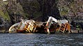
 Rum (Rùm) wreck JACK ABRY II (IMO 9305049) 1.jpg 5,184 × 3,456; 13.34 MB
-
 Rum (Rùm) wreck JACK ABRY II (IMO 9305049) 2.jpg 5,184 × 3,456; 11.83 MB
-
 Rum (Rùm) wreck JACK ABRY II (IMO 9305049) 3.jpg 4,608 × 3,456; 10.12 MB
-
 Rum (Rùm) wreck JACK ABRY II (IMO 9305049) 4.jpg 3,968 × 2,976; 7 MB
-
 Rum - ruined croft house at Port na Caronean (geograph 2374274).jpg 800 × 600; 190 KB
-
 Rum Ferry Terminal - geograph.org.uk - 3002398.jpg 640 × 424; 278 KB
-
 Rum from Sgurr an Duine - geograph.org.uk - 728448.jpg 640 × 426; 76 KB
-
 Sgùrr na Bà Glaise and Rois-Bheinn - Flickr - Graham Grinner Lewis.jpg 3,648 × 2,736; 2.59 MB
-
 Shielings above Sgòrr Reidh - geograph.org.uk - 761750.jpg 640 × 480; 74 KB
-
 Skerries off Inbhir Ghil - geograph.org.uk - 761808.jpg 640 × 480; 49 KB
-
-
 Slopes of Beinn na Seilg - geograph.org.uk - 740750.jpg 640 × 360; 48 KB
-
 Smirisary looking out to Eigg and Rum - geograph.org.uk - 1579164.jpg 640 × 429; 160 KB
-
 Southern tip of Sanday - geograph.org.uk - 304172.jpg 640 × 408; 112 KB
-
 Stac Suisnish - geograph.org.uk - 133235.jpg 640 × 480; 63 KB
-
 Standing Stone^ - geograph.org.uk - 151630.jpg 480 × 640; 154 KB
-
 Stream on the hillside above Loch Scresort (geograph 4567044).jpg 640 × 480; 565 KB
-
 Stream on the hillside above Loch Scresort (geograph 4567046).jpg 640 × 480; 507 KB
-
 Sunset Over Rum - geograph.org.uk - 778175.jpg 640 × 480; 50 KB
-
-
 The Ferry Pier on Rùm - geograph.org.uk - 2920776.jpg 640 × 480; 421 KB
-
 The ferry pier, Rum - geograph.org.uk - 2949640.jpg 800 × 518; 105 KB
-
 The mouth of the Morar - geograph.org.uk - 1159703.jpg 640 × 480; 44 KB
-
 The Scottish Islands. The Island of Rum, from Arisaig (NBY 441666).jpg 3,600 × 2,344; 1.57 MB
-
 Torridonian and Thrift (geograph 2919866).jpg 640 × 429; 517 KB
-
 Torridonian Beach (geograph 3002419).jpg 640 × 424; 252 KB
-
 Track at Kinloch (geograph 2391430).jpg 640 × 480; 392 KB
-
 Valley of Allt Shamhnan Insir - geograph.org.uk - 818436.jpg 480 × 640; 84 KB
-
 Valtos Sandstone - geograph.org.uk - 3963541.jpg 640 × 405; 425 KB
-
 View over Wreck Bay - geograph.org.uk - 761747.jpg 480 × 640; 60 KB
-
 Walls at Port-na-Caranean (geograph 2919844).jpg 640 × 476; 550 KB
-
 Waymarker, Dibidil pony track - geograph.org.uk - 904110.jpg 640 × 480; 103 KB
-
 Wet Woodland (geograph 2920747).jpg 480 × 640; 592 KB
-
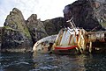
 Wreck of the Jack Abry II - geograph.org.uk - 6178136.jpg 1,280 × 720; 564 KB
-
 Wreck of the Jack Abry II - geograph.org.uk - 6178139.jpg 1,280 × 862; 600 KB
-

-
 Abandoned houses at Port-na-Caranean, Rum - geograph.org.uk - 153409.jpg 640 × 480; 126 KB
-
 Bealach an Dubh-bhraigh - geograph.org.uk - 28934.jpg 640 × 408; 46 KB
-
 Lava rocks - geograph.org.uk - 69402.jpg 640 × 425; 75 KB
-
 Moorland above Kinloch - geograph.org.uk - 28903.jpg 640 × 359; 50 KB
-
 North coast of Rum - geograph.org.uk - 520456.jpg 640 × 427; 263 KB


.jpg)


.jpg)


.jpg)
.jpg)
.jpg)
.jpg)
.jpg)
.jpg)


.jpg)


.jpg)
.jpg)
.jpg)


.jpg)


.jpg)
.jpg)


.jpg)
.jpg)
.jpg)
.jpg)

.jpg)


.jpg)

.jpg)
.jpg)


.jpg)

.jpg)
.jpg)


.jpg)
.jpg)
.jpg)
.jpg)
.jpg)
.jpg)
_1.jpg)
_2.jpg)
_wreck_JACK_ABRY_II_(IMO_9305049)_1.jpg)
_wreck_JACK_ABRY_II_(IMO_9305049)_2.jpg)
_wreck_JACK_ABRY_II_(IMO_9305049)_3.jpg)
_wreck_JACK_ABRY_II_(IMO_9305049)_4.jpg)
.jpg)


.jpg)
.jpg)


.jpg)
.jpg)
.jpg)
.jpg)


.jpg)

.jpg)


