Category:RAF Lymington
Jump to navigation
Jump to search
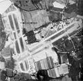
English: RAF Station Lymington is a former World War II airfield in Hampshire, England. The airfield is located approximately 1 mile (1.6 km) east of Lymington. It was opened in 1944, and used by the Royal Air Force, Canadian and the United States Army Air Forces. It was closed in 1946.
| Object location | | View all coordinates using: OpenStreetMap |
|---|
RAF airbase in England, UK  | |||||
| Upload media | |||||
| Instance of |
| ||||
|---|---|---|---|---|---|
| Location | |||||
| Operator | |||||
| Inception |
| ||||
| Dissolved, abolished or demolished date |
| ||||
 | |||||
Media in category "RAF Lymington"
The following 4 files are in this category, out of 4 total.
-
 Lymington-22may44.jpg 600 × 584; 79 KB
-
 Gatehouse on corner of Shotts Lane - geograph.org.uk - 174731.jpg 640 × 480; 161 KB
-
 Plaque about Lymington Airfield 1940s - geograph.org.uk - 174714.jpg 640 × 488; 157 KB
-


