Category:Raby Road bridge, Neston
Jump to navigation
Jump to search
| Object location | | View all coordinates using: OpenStreetMap |
|---|
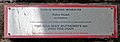
The bridge carries the Borderlands Line over Raby Road, Neston. It is numbered WDB3/29 and is 8.74 miles from the datum at Bidston. WBD3 is the Bidston Dee Junction to Dee Marsh West Junction line.
Media in category "Raby Road bridge, Neston"
The following 5 files are in this category, out of 5 total.
-
 Neston railway station (23).JPG 4,320 × 3,240; 3.58 MB
-
 Raby Road bridge plate.jpg 4,740 × 1,660; 4.33 MB
-
 Raby Road bridge vent, Neston.jpg 3,264 × 4,728; 11.99 MB
-
 Raby Road bridge, Neston 1.jpg 5,184 × 3,456; 7.24 MB
-
 Raby Road bridge, Neston 2.jpg 5,184 × 3,456; 7.88 MB
.JPG)


