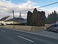
Category:Radeburger Straße 6, Mauer (Volkersdorf)
Jump to navigation
Jump to search
 | |||||
| Upload media | |||||
| Instance of | |||||
|---|---|---|---|---|---|
| Location | Radeburg, Meissen District, Saxony, Germany | ||||
| Street address |
| ||||
| Heritage designation | |||||
| Inception |
| ||||
 | |||||
| (Wikidata) |
Media in category "Radeburger Straße 6, Mauer (Volkersdorf)"
The following 5 files are in this category, out of 5 total.
-
 Radeburger Straße 6 Mauer volkersdorf 2021-03-06 1.jpg 3,648 × 2,736; 2.37 MB
-
 Radeburger Straße 6 Mauer volkersdorf 2021-03-06 2.jpg 3,648 × 2,736; 2.45 MB
-
 Radeburger Straße 6 Mauer volkersdorf 2021-03-06 3.jpg 5,120 × 3,840; 4.18 MB
-
 Radeburger Straße 6 Mauer volkersdorf 2021-03-06 4.jpg 5,120 × 3,840; 7.25 MB
-
 Radeburger Straße 6 Mauer volkersdorf 2021-03-06 5.jpg 3,648 × 2,736; 2.78 MB


