Category:Rail transport maps of Orne
Jump to navigation
Jump to search
Media in category "Rail transport maps of Orne"
The following 7 files are in this category, out of 7 total.
-
 Railway map of France - 61 - 1900 - fr - small.svg 705 × 879; 7.05 MB
-
 Railway map of France - 61 - 1914 - fr - small.svg 705 × 879; 7.18 MB
-
 Railway map of France - 61 - 1930 - fr - small.svg 705 × 879; 7.21 MB
-
 Railway map of France - 61 - 1980 - fr - small.svg 705 × 879; 7.1 MB
-
 Railway map of France - 61 - 2020 - fr - small.svg 705 × 879; 6.9 MB
-
 Railway map of France - 61 - animated - fr.gif 1,566 × 1,952; 4.87 MB
-
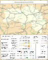
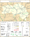
 Réseau ferré de l'Orne.svg 1,061 × 651; 59 KB


