Category:Rapenburg 102, Leiden
Jump to navigation
Jump to search
| Object location | | View all coordinates using: OpenStreetMap |
|---|
 | |||||
| Upload media | |||||
| Instance of |
| ||||
|---|---|---|---|---|---|
| Location | Leiden, South Holland, Netherlands | ||||
| Heritage designation |
| ||||
 | |||||
|
This is a category about rijksmonument number 25568
|
| Address |
|
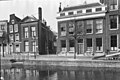
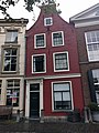
Media in category "Rapenburg 102, Leiden"
The following 9 files are in this category, out of 9 total.
-
 Exterieur OVERZICHT VOORGEVELS - Leiden - 20263764 - RCE.jpg 1,200 × 800; 186 KB
-
 Exterieur VOORGEVELS - Leiden - 20263765 - RCE.jpg 760 × 1,200; 160 KB
-
 Gevel - Leiden - 20137309 - RCE.jpg 1,200 × 802; 203 KB
-
 Leiden - Rapenburg 102-1.JPG 2,736 × 3,648; 4.82 MB
-
 Leiden - Rapenburg 102.jpg 3,024 × 4,032; 2.11 MB
-
 Leiden - Rapenburg bij 102.jpg 2,736 × 3,648; 4.73 MB
-
 Voorgevel - Leiden - 20137307 - RCE.jpg 1,200 × 797; 205 KB
-
 Voorgevel - Leiden - 20137313 - RCE.jpg 1,200 × 805; 229 KB
-
 Wiki Takes Leiden 2017--3.jpg 2,603 × 4,654; 5.8 MB


