Category:Rathaus (Markstraße, Bad Münstereifel)
Jump to navigation
Jump to search
| Object location | | View all coordinates using: OpenStreetMap |
|---|
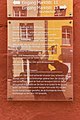
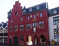
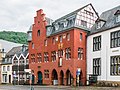
| This category shows a heritage building in Germany, located in the North Rhine-Westphalian city Bad Münstereifel (no. A 136). |
Media in category "Rathaus (Markstraße, Bad Münstereifel)"
The following 30 files are in this category, out of 30 total.
-
 2017-08-20-bad-muenstereifel-rathaus-01.jpg 5,184 × 3,456; 1.4 MB
-
 2017-08-20-bad-muenstereifel-rathaus-02.jpg 3,456 × 5,184; 1.28 MB
-
 2017-08-20-bad-muenstereifel-rathaus-03.jpg 3,456 × 5,184; 1.32 MB
-
 2017-08-20-bad-muenstereifel-rathaus-04.jpg 3,456 × 5,184; 1.01 MB
-
 2017-08-20-bad-muenstereifel-rathaus-05.jpg 3,456 × 5,184; 1.35 MB
-
 2019 04 14 Dieter GeB Bad Münstereifel (101).jpg 3,000 × 4,000; 4.67 MB
-
 2019 04 14 Dieter GeB Bad Münstereifel (102).jpg 4,000 × 3,000; 4.47 MB
-
 2019 04 14 Dieter GeB Bad Münstereifel (103).jpg 3,000 × 4,000; 4.75 MB
-
 2019 04 14 Dieter GeB Bad Münstereifel (104).jpg 4,000 × 3,000; 4.34 MB
-
 2019 04 14 Dieter GeB Bad Münstereifel (105).jpg 3,000 × 4,000; 4.87 MB
-
 2019 04 14 Dieter GeB Bad Münstereifel (106).jpg 3,000 × 4,000; 4.51 MB
-
 2019 04 14 Dieter GeB Bad Münstereifel (107).jpg 4,000 × 3,000; 3.99 MB
-
 2019 04 14 Dieter GeB Bad Münstereifel (113).jpg 4,000 × 3,000; 4.74 MB
-
 2019 04 14 Dieter GeB Bad Münstereifel (114).jpg 3,000 × 4,000; 4.52 MB
-
 2019 04 14 Dieter GeB Bad Münstereifel (115).jpg 3,000 × 4,000; 4.58 MB
-
 2019 04 14 Dieter GeB Bad Münstereifel (116).jpg 3,000 × 4,000; 4.7 MB
-
 2019 04 14 Dieter GeB Bad Münstereifel (117).jpg 3,000 × 4,000; 4.55 MB
-
 2019 04 14 Dieter GeB Bad Münstereifel (118).jpg 3,000 × 4,000; 4.76 MB
-
 2019 04 14 Dieter GeB Bad Münstereifel (119).jpg 3,000 × 4,000; 4 MB
-
 2019 04 14 Dieter GeB Bad Münstereifel (120).jpg 4,000 × 3,000; 4.47 MB
-
 Rotes Rathaus Bad Münstereifel.jpg 2,560 × 1,920; 606 KB
-
 Bad Münstereifel – Stadtverwaltung von der Fibergasse aus gesehen - panoramio.jpg 7,246 × 3,490; 2.06 MB
-
 Bad Münstereifel, das Rathaus.jpg 1,701 × 2,551; 1.08 MB
-
 Bad Münstereifel, Marktstraße 11-13-20160606-001.jpg 3,637 × 5,449; 10.05 MB
-
 Bad Münstereifel, Marktstraße 11-13-20160606-002.jpg 6,016 × 4,016; 12.32 MB
-
 Bad Münstereifel, Marktstraße 11-13-20160606-003.jpg 5,823 × 3,887; 11.96 MB
-
 Bad Münstereifel, Marktstraße 11-13-20160606-004.jpg 4,016 × 6,016; 11.9 MB
-
 Rathaus Bad Münstereifel.jpg 1,862 × 1,439; 1.67 MB
-
 Rathaus Marktstraße, Bad Münstereifel, rückwärtige Ansicht-9890.jpg 3,225 × 3,225; 6.52 MB
-
 Rathaus, Bad Münstereifel-183702.jpg 2,979 × 2,234; 4.15 MB


.jpg)
.jpg)
.jpg)
.jpg)
.jpg)
.jpg)
.jpg)
.jpg)
.jpg)
.jpg)
.jpg)
.jpg)
.jpg)
.jpg)
.jpg)


