Category:Rathaus mit Obertor (Hauptstrasse 2 / Vorstadtplatz 1, Laufen)
Jump to navigation
Jump to search
| Object location | | View all coordinates using: OpenStreetMap |
|---|
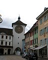
ensemble of buildings in Laufen in the canton of Basel-Landschaft, Switzerland _(cropped)_Rathaus_Obertor.jpg) Rathaus ganz links im Bild und Obertor in Bildmitte | |||||
| Upload media | |||||
| Instance of | |||||
|---|---|---|---|---|---|
| Part of | |||||
| Location | Laufen, Laufen District, Basel-Landschaft, Switzerland | ||||
| Street address |
| ||||
| Heritage designation | |||||
 | |||||
Media in category "Rathaus mit Obertor (Hauptstrasse 2 / Vorstadtplatz 1, Laufen)"
The following 2 files are in this category, out of 2 total.
-
 Altstadt (4893999178) (cropped) Rathaus Obertor.jpg 1,229 × 1,536; 701 KB
-
 Altstadt (4893999178).jpg 2,048 × 1,536; 1.41 MB
.jpg)