Category:Ravensmoor
Jump to navigation
Jump to search
English: Ravensmoor is a village in the unitary authority of Cheshire East and the ceremonial county of Cheshire, England, located at . It is split between the civil parishes of Baddiley and Burland. It lies at an elevation of 65 m, around 2¼ miles south west of Nantwich and 6 miles south west of Crewe.
village in Cheshire, United Kingdom  | |||||
| Upload media | |||||
| Instance of | |||||
|---|---|---|---|---|---|
| Location | |||||
 | |||||
Media in category "Ravensmoor"
The following 41 files are in this category, out of 41 total.
-
 Burland (Ravensmoor), Willowbrook Cottage - geograph.org.uk - 264123.jpg 640 × 480; 163 KB
-
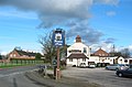
 Farmers Arms, Ravensmoor - geograph.org.uk - 2897278.jpg 640 × 480; 90 KB
-
 Farmers Arms, Ravensmoor Crossroads - geograph.org.uk - 2060147.jpg 640 × 480; 132 KB
-

-
 Farners Arms Ravensmoor.jpg 640 × 420; 110 KB
-
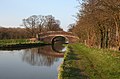 Halls Lane Bridge on the Shropshire Union - geograph.org.uk - 379531.jpg 640 × 423; 150 KB
-
 Llangollen Canal west of Ravensmoor, Cheshire - geograph.org.uk - 3221371.jpg 1,024 × 701; 412 KB
-
 Pasture near Baddiley Hall, Cheshire - geograph.org.uk - 3221254.jpg 1,280 × 685; 436 KB
-
 Pasture west of Ravensmoor, Cheshire - geograph.org.uk - 3221345.jpg 1,024 × 768; 624 KB
-
 Pasture west of Ravensmoor, Cheshire - geograph.org.uk - 3221715.jpg 1,024 × 598; 467 KB
-
 Ravensmoor - geograph.org.uk - 2060131.jpg 640 × 480; 176 KB
-
 Ravensmoor Church Cheshire.jpg 610 × 640; 126 KB
-
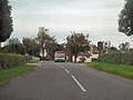 Ravensmoor Crossroads - geograph.org.uk - 2060140.jpg 640 × 480; 131 KB
-
 Ravensmoor Mill.jpg 640 × 480; 39 KB
-
 Ravensmoor windmill, Burland - geograph.org.uk - 1198464.jpg 640 × 455; 127 KB
-
 Shropshire Union at Baddiley Gorse - geograph.org.uk - 379548.jpg 640 × 427; 164 KB
-

-

-
 Stoneley Green Bridge near Ravensmoor, Cheshire - geograph.org.uk - 3200564.jpg 1,024 × 701; 452 KB
-

-
 The Farmer's Arms, Ravensmoor - geograph.org.uk - 5852633.jpg 1,280 × 851; 443 KB
-

-
 Brook at field boundary - geograph.org.uk - 379345.jpg 427 × 640; 166 KB
-
 Brook by Church Lane, Ravensmoor - geograph.org.uk - 379300.jpg 475 × 640; 166 KB
-

-
 Field near Manor House Farm - geograph.org.uk - 562946.jpg 640 × 480; 58 KB
-
 Field pond south west of Nantwich - geograph.org.uk - 1435186.jpg 640 × 480; 75 KB
-
 Fields near Fields Farm - geograph.org.uk - 562959.jpg 640 × 478; 92 KB
-
 Fields near Madam's Farm at sunset - geograph.org.uk - 706496.jpg 640 × 415; 111 KB
-

-
 House on Dig Lane - geograph.org.uk - 260231.jpg 640 × 484; 155 KB
-
 Madam's Farm, Raven's Lane, near Acton - geograph.org.uk - 706399.jpg 640 × 457; 164 KB
-
 Mere by Bethills Bridge - geograph.org.uk - 379626.jpg 640 × 454; 182 KB
-
 Pasture near Baddiley Corner - geograph.org.uk - 379377.jpg 478 × 640; 150 KB
-
 Pastureland by Bull's Wood - geograph.org.uk - 260237.jpg 640 × 468; 177 KB
-
 Private Road - geograph.org.uk - 562831.jpg 640 × 480; 104 KB
-
 Reflections in mere - geograph.org.uk - 379211.jpg 640 × 427; 191 KB
-
 Small mere, near Edleston Brook - geograph.org.uk - 344565.jpg 640 × 480; 147 KB
-

-
 Spinners Wood, Ravensmoor - geograph.org.uk - 344569.jpg 640 × 504; 163 KB
-
 Tree-lined footpath - geograph.org.uk - 379482.jpg 444 × 640; 177 KB
,_Willowbrook_Cottage_-_geograph.org.uk_-_264123.jpg)


_near_Ravensmoor,_Cheshire_-_geograph.org.uk_-_1706251.jpg)


