Category:Rechthuis, Westzaan
Jump to navigation
Jump to search
| Object location | | View all coordinates using: OpenStreetMap |
|---|
 | |||||
| Upload media | |||||
| Instance of | |||||
|---|---|---|---|---|---|
| Location | Westzaan, Westzaan | ||||
| Street address |
| ||||
| Located on street |
| ||||
| Heritage designation |
| ||||
 | |||||
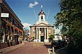
English: Former town hall designed by the architect Johan Samuel Creutz (1777-1787) and built in 1781-1783.
|
This is a category about rijksmonument number 40005
|
| Address |
|
Media in category "Rechthuis, Westzaan"
The following 50 files are in this category, out of 50 total.
-
 Achtergevel na restauratie - Westzaan - 20255085 - RCE.jpg 1,200 × 960; 280 KB
-
 Detail beeldhouwwerk in raadzaal - Westzaan - 20255092 - RCE.jpg 1,195 × 1,200; 304 KB
-
 Exterieur naar het noord-westen - Westzaan - 20255072 - RCE.jpg 883 × 1,200; 186 KB
-
 Exterieur naar het noord-westen - Westzaan - 20255073 - RCE.jpg 877 × 1,200; 182 KB
-
 Exterieur naar het noorden - Westzaan - 20255071 - RCE.jpg 886 × 1,200; 154 KB
-
 Former town hall Westzaan.jpg 1,050 × 700; 260 KB
-
 Gebeeldhouwd medaillon in raadzaal - Westzaan - 20255089 - RCE.jpg 1,195 × 1,200; 228 KB
-
 Gebeeldhouwd medaillon in raadzaal - Westzaan - 20255090 - RCE.jpg 1,192 × 1,200; 226 KB
-
 Gebeeldhouwd ornament in raadzaal - Westzaan - 20255095 - RCE.jpg 1,185 × 1,200; 287 KB
-
 Het Reghthuys Banne Westzaan - binnen.jpg 3,072 × 2,048; 2.65 MB
-
 Het Reghthuys Banne Westzaan - zijkant.jpg 2,048 × 3,072; 2.29 MB
-
 Het Reghthuys Banne Westzaan.jpg 2,048 × 3,072; 2.91 MB
-
 INT. RAADSZAAL, KLEURENTRAP OP VROUWE JUSTITIA - Westzaan - 20309789 - RCE.jpg 1,200 × 1,190; 269 KB
-
 INT. RAADSZAAL, VROUWE JUSTITIA - Westzaan - 20309788 - RCE.jpg 1,200 × 1,191; 217 KB
-

-
 Interieur raadzaal met toegangsdeuren - Westzaan - 20255087 - RCE.jpg 1,200 × 960; 201 KB
-
 Interieur raadzaal na restauratie - Westzaan - 20255086 - RCE.jpg 1,200 × 960; 189 KB
-
 Interieur raadzaal na restauratie - Westzaan - 20357207 - RCE.jpg 1,200 × 1,188; 195 KB
-

-
 Interieur raadzaal schoorsteenwand na restauratie - Westzaan - 20357209 - RCE.jpg 1,191 × 1,200; 169 KB
-
 Interieur schouw met justitiabeeld in raadzaal - Westzaan - 20255100 - RCE.jpg 894 × 1,200; 155 KB
-
 Linkerzijgevel na restauratie - Westzaan - 20255082 - RCE.jpg 1,200 × 957; 312 KB
-
 Ornament in raadzaal - Westzaan - 20255093 - RCE.jpg 1,185 × 1,200; 295 KB
-
 Ornament in raadzaal - Westzaan - 20255094 - RCE.jpg 1,185 × 1,200; 244 KB
-
 Overzicht - Westzaan - 20255097 - RCE.jpg 952 × 1,200; 204 KB
-
 Overzicht achtergevel met kerk na restauratie - Westzaan - 20255083 - RCE.jpg 1,200 × 960; 195 KB
-
 Overzicht achtergevel met kerk na restauratie - Westzaan - 20255084 - RCE.jpg 1,200 × 960; 263 KB
-

-
 Overzicht voorgevel na restauratie - Westzaan - 20255079 - RCE.jpg 1,200 × 950; 236 KB
-
 Raadhuis, voormalig Rechthuis - Westzaan - 20255070 - RCE.jpg 960 × 1,200; 212 KB
-
 Raadzaal - Westzaan - 20255075 - RCE.jpg 1,200 × 950; 204 KB
-
 Reliëf boven deuren in raadzaal - Westzaan - 20255091 - RCE.jpg 1,195 × 1,200; 228 KB
-
 Schoorsteenmantel kamer begane grond links - Westzaan - 20255096 - RCE.jpg 960 × 1,200; 174 KB
-
 Schouw - Westzaan - 20255077 - RCE.jpg 957 × 1,200; 179 KB
-
 Schouw in secretarie - Westzaan - 20255076 - RCE.jpg 951 × 1,200; 187 KB
-
 Stadhuis en kerk naar een oude gravure - Westzaan - 20255074 - RCE.jpg 1,200 × 881; 306 KB
-
 Toren en gedeelte voorgevel na restauratie - Westzaan - 20255081 - RCE.jpg 951 × 1,200; 158 KB
-
 Voorgevel - Westzaan - 20255098 - RCE.jpg 946 × 1,200; 199 KB
-
 Voorgevel - Westzaan - 20255099 - RCE.jpg 954 × 1,200; 200 KB
-
 Voorgevel - Westzaan - 20357204 - RCE.jpg 1,194 × 1,200; 284 KB
-
 Voorgevel - Westzaan - 20357205 - RCE.jpg 1,190 × 1,200; 247 KB
-

-
 Voorgevel na restauratie - Westzaan - 20255080 - RCE.jpg 953 × 1,200; 197 KB
-

-

-

-
 Westzaan - Raadhuis.jpg 3,315 × 4,974; 3.43 MB
-

-

-
 Westzaan, Kerkbuurt, Het Raadhuis, c. 1900-1930.jpg 1,712 × 1,144; 344 KB


_1781-1783_by_Johan_Samuel_Creutz_01.jpg)
_1781-1783_by_Johan_Samuel_Creutz_02.jpg)
_1781-1783_by_Johan_Samuel_Creutz_03.jpg)

_1781-1783_by_Johan_Samuel_Creutz.jpg)
_1781-1783_by_Johan_Samuel_Creutz.jpg)
