Category:Reformierte Kirche Unterentfelden
Jump to navigation
Jump to search
| Object location | | View all coordinates using: OpenStreetMap |
|---|
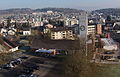
church tower in Unterentfelden in the canton of Aargau, Switzerland  | |||||
| Upload media | |||||
| Instance of | |||||
|---|---|---|---|---|---|
| Part of | |||||
| Location | Unterentfelden, Aarau District, Aargau, Switzerland | ||||
| Street address |
| ||||
| Inception |
| ||||
 | |||||
Media in category "Reformierte Kirche Unterentfelden"
The following 7 files are in this category, out of 7 total.
-
 Unterentfelden 2015-02-20 01.jpg 4,384 × 2,466; 3.81 MB
-
 Unterentfelden preghejo 067.jpg 3,872 × 2,592; 3.75 MB
-
 Unterentfelden preghejo 068.jpg 3,872 × 2,592; 4.16 MB
-
 Unterentfelden preghejo 069.jpg 3,872 × 2,592; 4.16 MB
-
 Unterentfelden Ref Kirche 2015-02-20 01.jpg 2,296 × 1,612; 1.15 MB
-
 Unterentfelden Ref Kirche 2015-02-20 02.jpg 2,280 × 1,456; 918 KB
-
 Unterentfelden Ref Kirche 2015-02-20 03.jpg 2,040 × 1,412; 927 KB


