Category:Reigerstraat 6, Breda
Jump to navigation
Jump to search
| Object location | | View all coordinates using: OpenStreetMap |
|---|
building in Breda, Netherlands  | |||||
| Upload media | |||||
| Instance of | |||||
|---|---|---|---|---|---|
| Location | Breda, North Brabant, Netherlands | ||||
| Street address |
| ||||
| Heritage designation |
| ||||
 | |||||
|
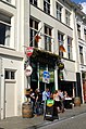
This is a category about rijksmonument number 10285
|
| Address |
|
Media in category "Reigerstraat 6, Breda"
The following 6 files are in this category, out of 6 total.
-
 O'Mearas Irish Pub DSCF2083.JPG 2,112 × 2,816; 2.55 MB
-
 O'Mearas Irish Pub DSCF5651.jpg 1,864 × 2,816; 2.47 MB
-
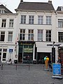 Reigerstraat 6, Breda DSCF0157.jpg 1,536 × 2,048; 1.53 MB
-
 RM10285 RM10284 Breda - Reigerstraat 6 en 4.jpg 1,944 × 2,592; 1.28 MB
-
 Voorgevel - Breda - 20041489 - RCE.jpg 830 × 1,200; 193 KB
-
 Voorgevels - Breda - 20041487 - RCE.jpg 834 × 1,200; 212 KB


