Category:Reijerskoop 196 (Boskoop)
Jump to navigation
Jump to search
| Object location | | View all coordinates using: OpenStreetMap |
|---|
 | |||||
| Upload media | |||||
| Instance of | |||||
|---|---|---|---|---|---|
| Part of | |||||
| Location | Boskoop, Boskoop | ||||
| Street address |
| ||||
| Heritage designation |
| ||||
 | |||||
|
This is a category about rijksmonumentcomplex number 524417
|
Boerderij:
|
This is a category about rijksmonument number 511499
|
Schuur:
|
This is a category about rijksmonument number 524418
|
Hooiberg:
|
This is a category about rijksmonument number 524419
|
| Address |
|
Media in category "Reijerskoop 196 (Boskoop)"
The following 4 files are in this category, out of 4 total.
-
 Overzicht boerderij vanaf de weg - Boskoop - 20374443 - RCE.jpg 1,195 × 1,200; 432 KB
-
 Reijerskoop 196, Boskoop - boerderij.JPG 3,072 × 2,304; 3.14 MB
-
 Reijerskoop 196, Boskoop - hooiberg.JPG 2,304 × 3,072; 3.08 MB
-
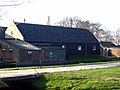 Reijerskoop 196, Boskoop - schuur.JPG 3,072 × 2,304; 2.82 MB


