Category:Remungol
Jump to navigation
Jump to search
former commune in Morbihan, France  .svg)  | |||||
| Upload media | |||||
| Pronunciation audio | |||||
|---|---|---|---|---|---|
| Instance of |
| ||||
| Location |
| ||||
| Dissolved, abolished or demolished date |
| ||||
| Population |
| ||||
| Area |
| ||||
| Elevation above sea level |
| ||||
| Replaced by | |||||
| official website | |||||
 | |||||
Subcategories
This category has the following 3 subcategories, out of 3 total.
Media in category "Remungol"
The following 10 files are in this category, out of 10 total.
-
 621 Remungol.jpg 4,310 × 3,226; 6.7 MB
-
 Blason ville fr Remungol (Morbihan).svg 600 × 660; 113 KB
-
 Cassini Evellys.jpg 921 × 900; 948 KB
-
 Map commune FR insee code 56192.png 756 × 605; 53 KB
-
 Noce bretonne Remungol 1920.jpg 993 × 603; 385 KB
-
 Population - Municipality code 56192.svg 475 × 355; 13 KB
-
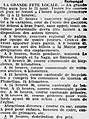
 Remungol 1884.jpg 710 × 392; 195 KB
-
 Remungol Fête locale 1925.jpg 434 × 582; 213 KB
-
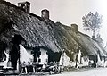 Remungol Rue du Bâtiment chaumières.jpg 1,572 × 1,116; 895 KB
-
 Remungol rue principale vers 1920.jpg 1,590 × 1,121; 805 KB


